Camp Fire
Camp Fire (also known as Branch III) update
Friday, August 14, 2026
Emergency Manager- Warren LaPlante
Evacuation Status Changes
After careful consideration of current fire conditions, firefighter operations, and the ongoing assessment of the Camp Fire, Lake County officials have determined that one evacuation zone change will take effect at 5 p.m. today.
The designated area of North Fall Lake 1A will be removed from SET status and will return to normal status, with no evacuation restrictions in place.
While these changes reflect current conditions, the Camp Fire remains active, and conditions can change rapidly. Residents in these areas should remain prepared to evacuate if conditions worsen.
The Evacuation Zone Map will be updated to reflect these changes at 5:00 p.m. Residents are encouraged to continue monitoring official Lake County communications for additional updates.
Firefighters and other emergency personnel remain actively engaged in operations throughout the affected areas. Residents and visitors are asked to remain alert and use caution near ongoing firefighting operations.
For additional information and the latest evacuation information, visit the Lake County website at https://lakecountymn.gov.
Camp Fire (also known as Branch III) update
Wednesday, August 12, 2026
Emergency Manager- Warren LaPlante
Evacuation Status Changes – Fernberg Corridor & Surrounding Lake County Areas
After careful consideration of current fire conditions, firefighter operations, and the ongoing assessment of the Camp Fire, Lake County officials have determined that several evacuation zone changes will take effect at 7:00 p.m. Wednesday, August 12.
Effective at 7:00 p.m.:
- Evacuation zone North Fall Lake 1A, directly surrounding the area where the Camp Fire originated will change from GO to SET.
- The Fernberg Corridor, the White Iron Chain of Lakes, and the other four North Fall Lake zones will have all evacuation levels removed.
While these changes reflect current conditions, the Camp Fire remains active, and conditions can change rapidly. Residents in these areas should remain prepared to evacuate if conditions worsen.
The Evacuation Zone Map will be updated to reflect these changes at 7:00 p.m. Residents are encouraged to continue monitoring official Lake County communications for additional updates.
Firefighters and other emergency personnel remain actively engaged in operations throughout the affected areas. Residents and visitors are asked to remain alert and use caution near ongoing firefighting operations.
For additional information and the latest evacuation information, visit the Lake County website at https://lakecountymn.gov.
Camp Fire (also known as Branch III) update
Wednesday, July 29, 2026
Emergency Manager- Warren LaPlante
Evacuation Zone Status Update
Fire response operations along with recent rains helped modify fire activity on the July Lightning Incident fires. After careful consideration, Lake County, in close consideration with the Incident Command Team, has further reduced evacuation zone areas that have been in effect. The following changes will be effective at 7:00 PM tonight, July 29, 2026:
- Zones North Fall Lake 2B, South Fall Lake, East and West Winton, Ojibway Lake, Moose Lake, and Snowbank Lake will be downgraded from a SET status to a READY status.
- Zones North Fall Lake 1B and 2A will remain in SET status.
- Zones North Fall Lake 2C, West Winton A, and North and South Silver Rapids will remain in READY status.
It is important to note that, despite these changes, the fire danger across Northern Minnesota is still moderate to high. Recent storms produced a significant amount of lightning, but precipitation was not consistent across the region. The public is encouraged to continue to use caution when visiting these areas and be prepared for the READY-SET-GO status to change as weather and fuel conditions evolve.
Emergency personnel and fire crews remain actively working throughout the incident area. Motorists and visitors are asked to use extra caution, watch for emergency vehicles and equipment on roadways, and give responders plenty of space to work safely.
For continued updates, please visit the Lake County website
Camp Fire (Branch III of the July Fire Incident) Update
Tuesday, July 28, 2026
Emergency Manager- Warren LaPlante
Evacuation Status Update – North Cedar Lake Area and Cloquet Line Road
Effective at 7:00 p.m. on Tuesday, July 28, the following evacuation status changes and road updates are in effect for the North Cedar Lake area and Cloquet Line Road in Lake County:
- The area North of Cedar Lake to the Cloquet Line Road that is currently under GO evacuation status is being downgraded to SET.
- Cloquet Line Road, from the boat launch to the St. Louis County line, is now open to local traffic.
If you must travel through this area, please use caution. Firefighters and other emergency personnel remain actively working throughout the area. Fire suppression operations, patrols, and monitoring continue, and your patience and cooperation are essential to keeping everyone safe.
Please continue to monitor official updates and be prepared to leave immediately if evacuation conditions change.

July Lightning Incident/Little Knife Fire Daily Update July 27, 2026
Inciweb: https://inciweb.wildfire.gov/incident-information/mnsuf-july-2026-superior-nf-wildfires
Facebook: https://www.facebook.com/SuperiorNF and https://www.facebook.com/mnics.org
Fire Information: 218-881-2091 (8:00 am–8:00 pm), 2026.JulyLightningEvent@firenet.gov
Recreation.gov Permit Questions: 218-626-4314
Media Inquiries: 218-219-0233
Canadian Fire Information: Ontario Wildfire Information
Fire and Smoke Map: fire.airnow.gov
City of Ely Webcams: https://www.ely.org/things-to-do/webcams/
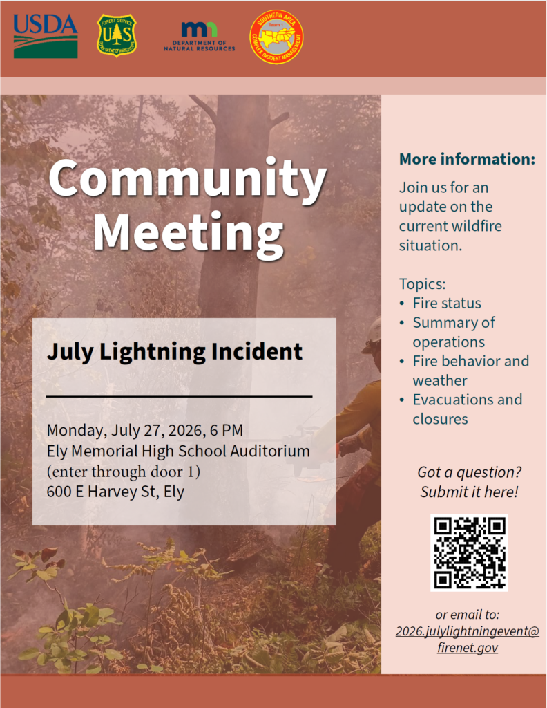
**A community meeting about the July Lightning Incident will be held tonight at 6 pm at the Ely Memorial High School Auditorium at 600 E Harvey Street, Ely, MN. An operational briefing about the fires will be presented and a live virtual option will be available on the Superior National Forest’s Facebook page (facebook.com/SuperiorNF). If you have a question you would like addressed, please email 2026.JulyLightningEvent@firenet.gov and write “Community Meeting Questions” in the subject line.
Summary
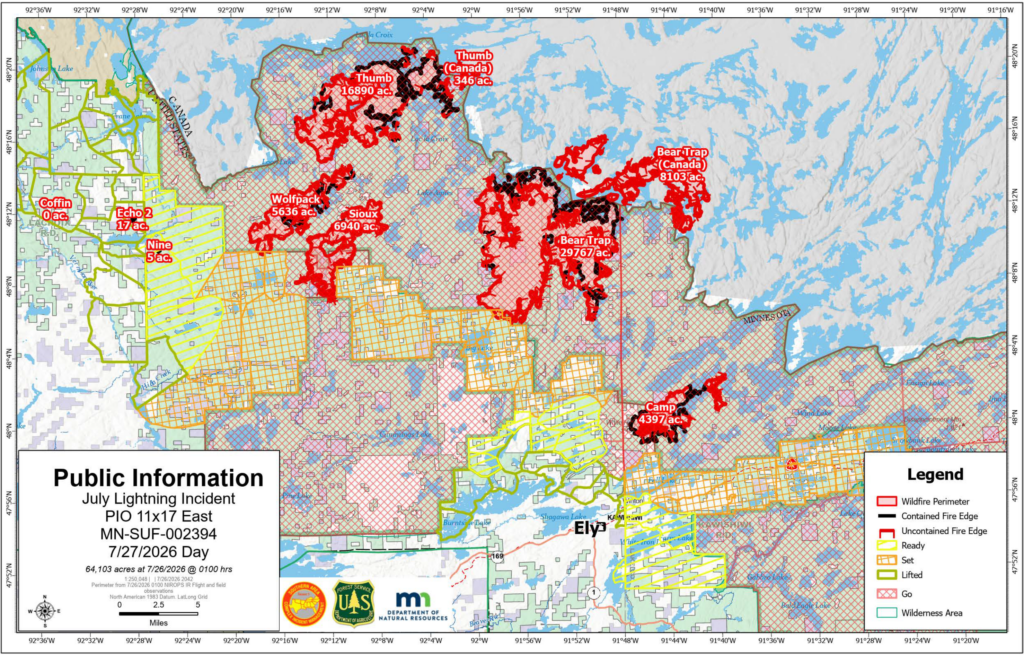
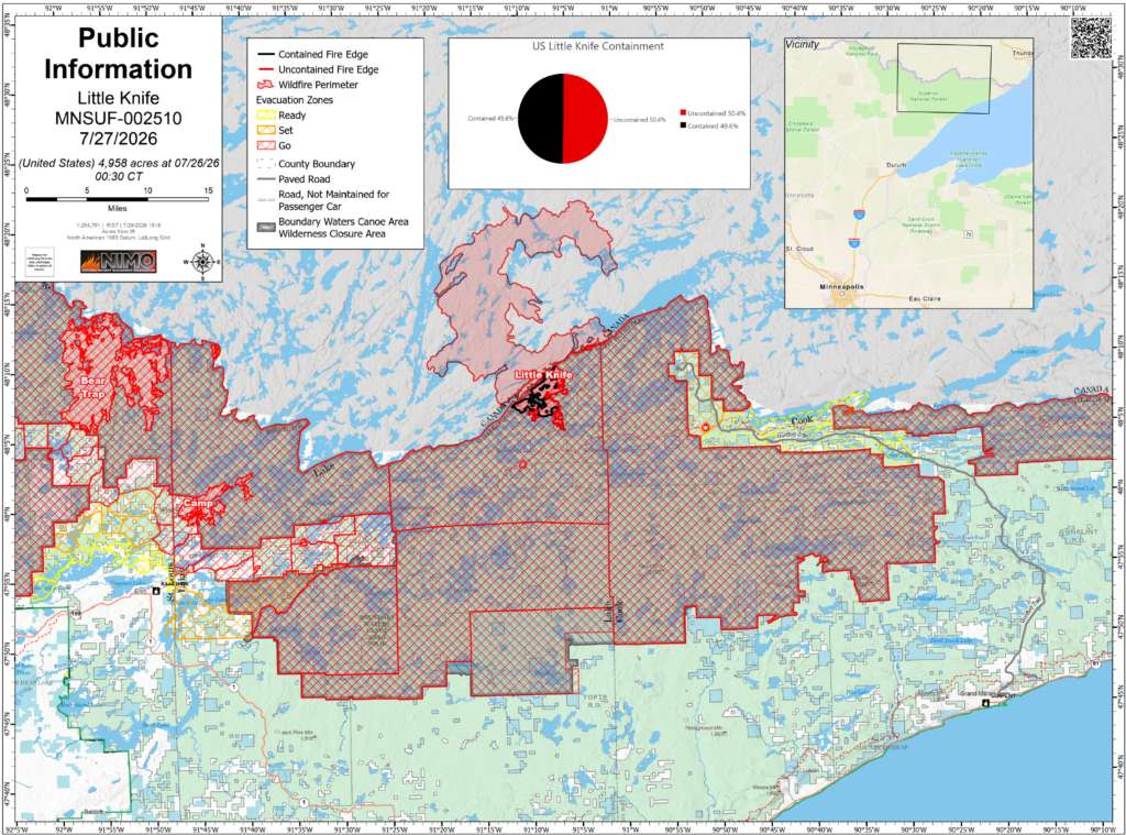
Overall combined acreage of the July Lightning Incident is 64,103 acres in the United States and an additional 8,443 acres in Canada. Estimated acreage of the Little Knife Fire is 4,958 acres. There is a total of 1,066 personnel on the July Lightning Incident and a total of 125 personnel on the Little Knife Fire. Containment estimates continue to fluctuate based on current fire behavior, fuels, weather and using natural barriers like lakes and waterways for containment perimeters. The public can support firefighters and their safety by adhering to all evacuations, closures, and fire restrictions; by refraining from flying drones, which endanger firefighting aircraft; and by keeping boats off the water in areas where water-gathering aircraft are operating.
Evacuations and Closures
An interactive map is available for residents and property owners to determine evacuation levels for their property. Residents and property owners can search this map by address to determine exact locations and evacuation levels. Click on the county name below for county-specific information.
Lake County: Most evacuations were downgraded on the evening of Sunday, July 26. Areas that were in “GO” status are now in “SET”. Areas that were in “SET” status are now in “READY”. North Fall Lake 1, located adjacent to the fire area, remains in “GO” status. A road closure will be in place at the Cedar Lake Boat Access and no traffic will be allowed beyond that point. Please view the Lake County evacuation zone map for more specific information.
St. Louis County: Most evacuations were downgraded on the evening of Sunday, July 26. Zones 200 and 201 along the Cloquet Line and Zone 100 along the Echo Trail will remain in “GO” status. All other evacuation zones currently in “GO” status will be downgraded to “SET”. All evacuation zones that had been “SET” are now in “READY” status. The entire Echo Trail will close daily between 9:30 am and 7 pm to protect the safety of firefighters and equipment still working. Please view the St. Louis County evacuation zone map for more specific information.
Cook County: Effective today, Monday July 27, “READY” status in Gunflint Districts two, three and four is removed. Gunflint District 1 is downgraded from “SET” to “READY”. The BWCA East district at “GO” will be removed and the BWCA West district at “GO” will be updated to follow the Forest Service map of the BWCA in Cook County that is open for daytrips starting Monday.
Superior National Forest: Forest Officials announced on July 24 that a Proposed Phase 2 plan – could be implemented this week barring no significant wildfire activity over this weekend. The proposed Phase 2 Plan would open select entry points on the eastern side of the Boundary Waters Canoe Area Wilderness (BWCAW) to overnight use. The Forest announced Phase 1 earlier this week that select BWCAW entry points will open to the public for ‘Day Use’ starting today, on the Gunflint and Tofte Districts (Eastern side of the forest), and BWCAW Overnight permits were cancelled through July 29, 2026. Daily, the Forest Service continues to evaluate the affected BWCAW quota permit entry point areas and other recreation areas outside the BWCAW in an effort to reopen select areas (as fire activity, weather and resources allows). A BWCAWClosure Order is in place to protect public and firefighter health and safety. The public is encouraged to monitor the forest’s Alerts webpage and recreation webpage for open and closed areas.
Temporary Flight Restrictions are in place over certain portions of the fire area. Reminder, there is a permanent flight restriction over the BWCAW. Visit the Federal Aviation Administration (FAA) website for more information.
Fire Restrictions
Superior National Forest Forest-wide Fire Restrictions are in effect.
Minnesota DNR fire restrictions are in effect.
Weather and Fire Behavior
Temperatures will continue to remain above normal the next few days as a portion of large-scale heat dome currently over the western US moves east over the fire area. Meanwhile, the jetstream will pass through the Upper Midwest as it rounds the periphery of the heat dome. This jetstream will periodically bring atmospheric disturbances into our region and give daily chances for showers and thunderstorms, mainly during the afternoon and evening.
Rain has moderated surface fire activity, but heat still remains in the duff below the surface.
Operations
Non-Boundary Waters Canoe Area Wilderness Wildfires
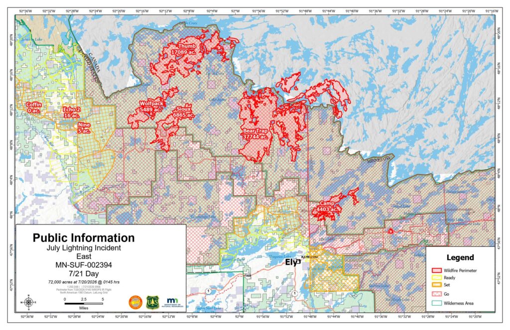
Camp: Approximately4,407 acres. 39% contained. Location – 5 miles north of Winton. Yesterday, crews mopped up along the southwestern flank of the fire and assessed structures on the Cloquet Line. Today crews will scout and plan for opportunities to construct fireline on the southeastern side of the fire and continue brushing along the Cloquet Line.
Sioux: Approximately 12,615 acres. 27% contained. Location – North of the Echo Trail and east of Jeanette Campground. Portions of the fire are burning in BWCAW. Yesterday, crews continued extensive mop up south of Echo Trail. Today, crews will widen the fuel break on Echo Trail to at least 100 feet. Structure protection continues in the Moose Loop and Meander Lake areas.
Boundary Waters Canoe Area Wilderness Wildfires
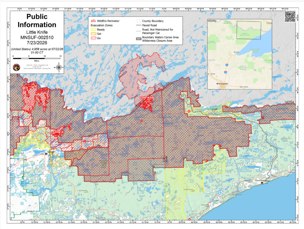
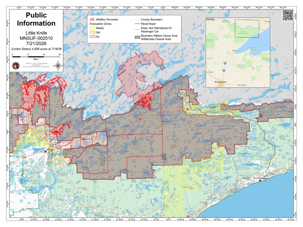
Little Knife: Originated in Ontario and crossed into the United States. Approximately 4,958 acres. 49% contained. A hotshot crew continues to work the eastern perimeter, traveling by canoe to improve portages as control features between lakes. 12 smokejumpers and two specialized wildland fire modules were also deployed to the southwestern and eastern sides of the fire. No significant fire behavior is expected today, however heat remains in the duff beneath the surface. Managed by the National Incident Management Organization (NIMO).
Bear Trap (Bear Trap and Dark Fires combined): Approximately 37,837 total acres (29,767 acres in the United States). 38% contained. Location – South of Lac La Croix, 20 miles north of Ely. Yesterday, crews made progress widening the fuel break on Echo Trail to at least 100 feet. Chipping around structures at Big Lake continues today and masticators are brushing along Angleworm trail.
Thumb: 17,236 total acres (16,890 acres in the United States). 56% contained. Remote and located 6 miles south of Gakijiwanong Anishnaabe Nation Canada. Yesterday, a hotshot crew demobilized from the fire via watercraft and today the fire will be unstaffed.
Wildfires West of Echo Lake and East of U.S. Hwy 53
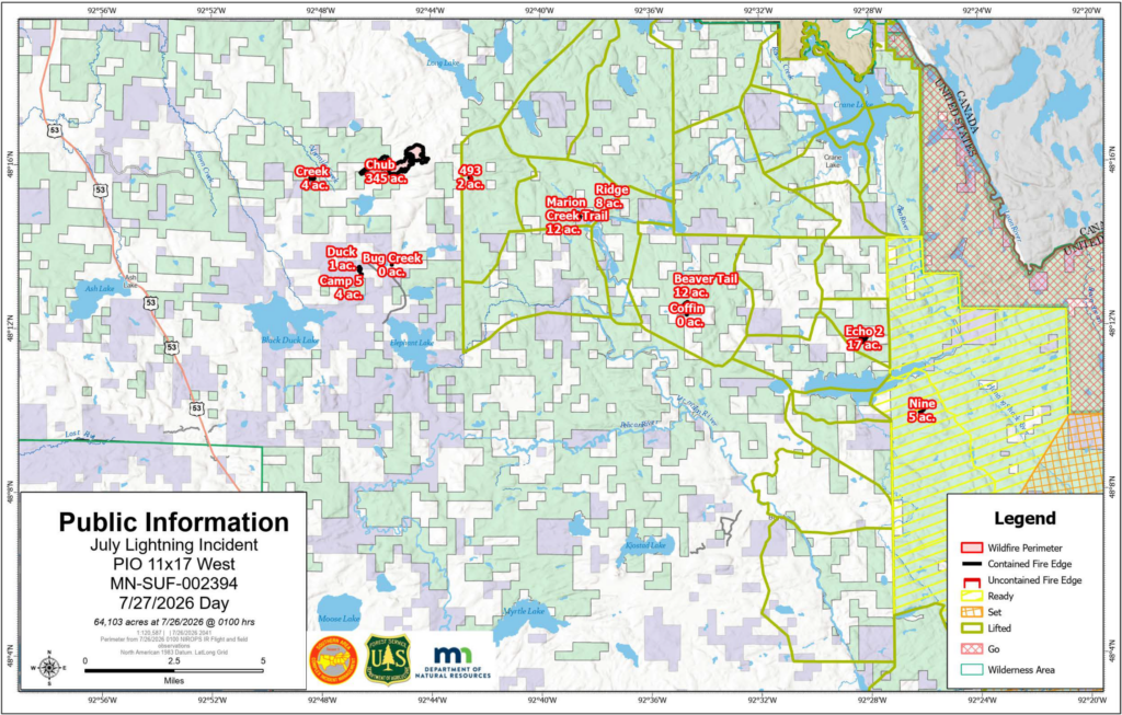
Chub: 344 acres. 95% contained. Location – North of Chub Lake, southwest of Crane Lake. Crews will continue with mop up to extinguish pockets of heat throughout the fire.
493, Echo 2, Beaver Tail, Ridge, Creek, Marion Creek Trail, Nine, Camp 5/Duck, Bug Creek, Coffin Fires: 64.4 acres combined for all ten fires. All are 100% contained. Crews continue to patrol these fires, searching for smoke and hot spots and extinguishing any lingering heat.
Long Lake Fire: 15 acres. Crews will continue with mop up to extinguish pockets of heat throughout the fire.
Local DNR Managed Fires
Little Lake and 614 Fires: For information contact Leanne Langeberg, MNMNCC_information@firenet.gov.
For a glossary of fire terminology visit this site.
History
On the evening of July 6, a dry thunderstorm moved across northeastern Minnesota and southern Canada resulting in more than 1,000 lightning strikes, causing dozens of fire starts. As unprecedented dry and warm conditions followed in the days after, fires were detected across Cook, Lake and St. Louis counties. Where fires were accessible by ground, firefighters kept some of the fire perimeters small in size, but due to the number of fires, locations and number of firefighters and equipment, some of the fires continued to smolder and grow in the following days. Local fire managers ordered many additional resources including engines, hand crews, aviation resources and two incident management teams to support firefighting efforts. While some of the fires were contained, several have continued to grow due to record-breaking high temperatures and low humidity. Additional firefighters, equipment and support staff continue to be ordered as needed.
Public Information
July Lightning Event/Little Knife Fire
Superior National Forest
Fire Information: 218-881-2091
Media Phone Line: 218-219-0233
Facebook: https://www.facebook.com/SuperiorNF
Inciweb: https://inciweb.wildfire.gov/incident-information/mnsuf-july-2026-superior-nf-wildfires
Camp Fire (Branch III of the July Fire Incident) Update
Sunday, July 26, 2026
Emergency Manager- Warren LaPlante
Evacuation Status Update – Fernberg Corridor & Surrounding Lake County Areas
Effective at 7:00 p.m. on Sunday, July 26, the following evacuation status changes will take effect for the Fernberg Corridor and surrounding Lake County areas:
- Most areas currently under “GO” status will be downgraded to “SET.” Property owners may return to these areas. Because fire conditions can evolve quickly, those who return to the SET areas should still be prepared to leave immediately if conditions worsen.
- One area will remain under “GO” status: the area located adjacent to the fire area will remain evacuated.
- A road closure will be in place at the Cedar Lake Boat Access. No traffic will be allowed beyond this point.
- Areas currently under “SET” status will be downgraded to “READY.”
- The Evacuation Zone Map will not reflect these changes until 7:00 p.m.
As people return, please remember that firefighters and other emergency personnel remain actively working throughout the area. Fire suppression operations, patrols, and monitoring continue, and your patience and cooperation are essential to keeping everyone safe.
Please use caution while traveling and on your property. Property owners should be aware that hoses, sprinklers, pumps, water tanks and other firefighting equipment that was placed by firefighters to protect structures should be left in place. This equipment is needed as a precaution should fire activity increase and will be removed once fire operations are completed.
What These Evacuation Levels Mean
SET: You may return to your property, but conditions can change quickly. Continue monitoring official information and remain prepared to evacuate immediately if conditions worsen. Keep your vehicle fueled, important belongings ready, and your evacuation plan in place.
READY: There is currently no immediate need to evacuate, but the wildfire remains active. Stay informed, review your evacuation plan, and be prepared to act if conditions change and evacuation levels increase.
As a reminder, most Superior National Forest lands both within and outside the BWCAW affected by wildfires remain temporarily closed to the public for fire suppression activities and to ensure public and firefighter safety. The forest is continually looking at opportunities to modify closure areas as conditions improve and areas are deemed safe for public recreation. Please continue to monitor the forest’s Alerts webpage and recreation webpage for open and closed areas: https://www.fs.usda.gov/r09/superior/alerts
Thank you for your continued patience and cooperation as crews work to secure the fire and protect the community.

July Lightning Incident/Little Knife Fire Daily Update July 23, 2026, 10:00 am
Inciweb: https://inciweb.wildfire.gov/incident-information/mnsuf-july-2026-superior-nf-wildfires
Facebook: https://www.facebook.com/SuperiorNF and https://www.facebook.com/mnics.org
Fire Information: 218-881-2091 (8:00 am–8:00 pm), 2026.JulyLightningEvent@firenet.gov
Recreation.gov Permit Questions: 218-626-4314
Media Inquiries: 218-219-0233
Canadian Fire Information: Ontario Wildfire Information
Fire and Smoke Map: fire.airnow.gov
Executive Summary
Today, the July Lightning Incident Command Post (ICP) will move from Memorial High School in Ely to Fortune Bay Resort Casino in Tower, so the district can prepare to welcome students back to school. The Southern Area CIMT 1 wants to thank school district staff for their kindness and hospitality. Best of luck in the upcoming school year!
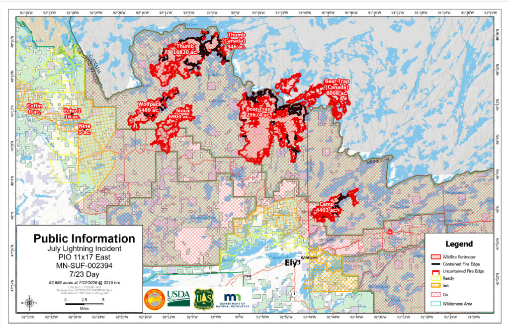
Combined acreage overall of the July Lightning Incident is 63,696 acres in the United States and an additional 8,443 acres in Canada. Estimated acreage of the Little Knife Fire is 4,958 acres. There are a total of 1,029 personnel on the July Lightning Incident. Containment estimates continue to increase based on current fire behavior, fuels, weather and natural barriers like lakes and waterways. Containment is a dynamic figure and can rise and fall based on fire activity. The public is being asked to support firefighters and public safety by adhering to all evacuations, closures, and fire restrictions; by refraining from flying drones, which endanger firefighting aircraft; and by keeping boats off the water in areas where water-gathering aircraft are operating. Fires reported on this update may change as some fires have merged or been moved into patrol status.
Evacuations and Closures
An interactive map is available for residents and property owners to determine evacuation levels for their property. Residents and property owners can search this map by address to determine exact locations and evacuation levels. Click on the county name below for county-specific information.
Lake County: All evacuations remain in place. This morning, the Lake County Sheriff’s Office provided temporary escorted re-entry for a limited number of residents and property owners affected by the Camp Fire.
St. Louis County: “Ready” and “Set” zones west of the Echo Trail and the Crane Lake area have been completely lifted. Please visit the St. Louis County Emergency Management website for more information. St Louis County is not offering escorted re-entry of any of the “Go” evacuation areas at this time due to fire behavior and proximity to the fire area.
Cook County: The “READY” evacuations for Schroeder – Dist. 1, Tofte – Dist.1, and Lutsen – Dist. 1 have been lifted as of Wednesday, July 22 due to a reduction of fire behavior potential on the Little Knife Fire. The Gunflint Trail is still in “SET” and “READY” status between the end of the Gunflint Trail and mid-trail.
Superior National Forest: The Forest announced this morning select BWCAW entry points will open to the public for ‘Day Use’ on July 27, on the Gunflint and Tofte Districts (Eastern side of the forest), and BWCAW ‘Overnight’ permits will be cancelled July 25 – July 29, 2026. Forest Officials anticipate the ability to open select portions this next week to overnight use – barring no significant wildfire activity over the upcoming weekend. In an effort to re-open select areas of the BWCAW (as fire activity, weather and resources allows) the Forest Service continues to evaluate the affected BWCAW quota permit entry point areas for use on a daily basis. A Boundary Waters Canoe Area Wilderness (BWCAW) Closure Order is in place to protect public and firefighter health and safety.
Temporary Flight Restrictions are in place over certain portions of the fire area. Visit the Federal Aviation Administration (FAA) website for more information.
Fire Restrictions
Superior National Forest Forest-wide Fire Restrictions are in effect.
Minnesota DNR fire restrictions are in effect.
Weather and Fire Behavior
Stronger southwesterly winds will continue to bring warmer temperatures over the fire area into the weekend. Highs are forecast to reach the mid 80s while relative humidities will fall into the mid 30s to lower 40s. The combination of winds and hot, dry air will create elevated fire weather conditions, particularly on Friday. A 30% chance of rain showers exists today, but better chances for rain arrive late Friday.
The small chance of afternoon showers is not predicted to impact fire behavior today. While today may not see significant fire spread, expect momentum to continue building as surface fire and isolated torching begin to increase in areas that have been relatively quiet.
Operations
Non-Boundary Waters Canoe Area Wilderness Wildfires
- Camp: Approximately 4,402 acres. 23% contained. Location – 5 miles north of Winton. Yesterday, helicopters dropped buckets of water on hot spots and crews finished constructing direct and indirect line along the southern and western fire perimeters. Today, crews will mop up along the southern fire perimeter and continue with structure protection along Fernberg Road towards Snowbank.
- Sioux: Approximately 12,392 acres. 17% contained. Location – North of the Echo Trail and east of Jeanette Campground. Portions of the fire are burning in BWCAW. Yesterday, helicopters dropped buckets of water on hot spots and crews cleared trees and vegetation along Forest Road 199. Today, crews will continue clearing vegetation along Echo Trail and mop up hot spots south of Echo Trail.
Boundary Waters Canoe Area Wilderness Wildfires - Little Knife: Originated in Ontario and crossed into the United States. Fire activity was minimal on the Little Knife Fire yesterday and the fire remains at 4,958 acres. About 55 personnel are assigned, with engines assessing structures along the Gunflint Trail and incoming specialized crews preparing for strategic suppression in the BWCAW. Managed by the National Incident Management Organization (NIMO).
- Bear Trap (Bear Trap and Dark Fires combined): Approximately 37,780 total acres (29,682 acres in the United States). 34% contained. Location – South of Lac La Croix, 20 miles north of Ely. Yesterday, helicopters dropped buckets of water on hot spots on the southern and western perimeters of the fire and continued structure protection around Big Lake. Today, crews will continue structure protection and clearing and widening Echo Trail to the east to connect the Echo Trail to the Camp Fire and to the west towards the Sioux Fire.
- Thumb: 17,164 total acres (16,820 acres in the United States). 58% contained. Remote and located 6 miles south of Gakijiwanong Anishnaabe Nation Canada. Yesterday, scooper planes were used on the northern and western perimeters of the fire, while a hotshot crew was inserted into the northern portion of the fire area. Today, the hotshot crew on the northwestern edge of the fire near Takucmich Lake, south of Lac La Croix, will construct fireline and install sprinklers.
Wildfires West of Echo Lake and East of U.S. Hwy 53
The Chub Fire is the most active fire in this area. There is a combined containment of 87% on these eleven fires. Crews are identified to assist with initial attack for any new fires that are detected. - Chub: 344 acres. 86% contained. Location – North of Chub Lake, southwest of Crane Lake. Crews have secured dozer line and handlines and will continue with mop up to extinguish pockets of heat throughout the fire interior.
- 493, Echo 2, Beaver Tail, Ridge, Creek, Marion Creek Trail, Nine, Camp 5/Duck, Bug Creek, Coffin Fires: 64.4 acres combined for all ten fires. All are 100% contained. Crews continue to patrol these fires, searching for smoke and hot spots and extinguishing any lingering heat.
History
On the evening of July 6, a dry thunderstorm moved across northeastern Minnesota and southern Canada resulting in more than 1,000 lightning strikes, causing dozens of fire starts. As unprecedented dry and warm conditions followed in the days after, fires were detected across Cook, Lake and St. Louis counties. Where fires were accessible by ground, firefighters were able to work to keep some of the fire perimeters small in size, however due to the number of fires, locations and number of firefighters and equipment, some of the fires continued to smolder and grow in the following days. Local fire managers ordered many additional resources including engines, hand crews, aviation resources and two incident management teams to support the firefighting efforts. While some of the fires were contained, several have continued to grow due to record breaking high temperatures and low humidity. Additional firefighters, equipment and support staff continue to be ordered including a Complex Incident Management Team.
July 22, 2026
Property Access for Residents Affected by the Camp (Branch III) Fire Closure
The Lake County Sheriff’s Office, in collaboration with the Southern Area Complex Incident Management Team, will provide an opportunity for residents and property owners affected by the Camp (Branch III) Fire closure to access their properties on Thursday, July 23, 2026, from 8:00 a.m. to 2:00 p.m.
Property owners and authorized individuals must present identification to verify residency, property ownership, or other authorized access. Acceptable documentation includes:
- Driver’s license or state-issued identification card
- Utility bill
- Property tax statement
- Voter registration card or other documentation demonstrating residency or property ownership
Additional documentation may be accepted at the discretion of the Lake County Sheriff’s Office.
Escort Procedure
- Check-in will begin at 7:30 a.m. at the Fall Lake Township Hall, located at 393 Kawishiwi Trail, Ely, MN 55731.
- After check-in, participants will receive an access pass and be escorted by Lake County Sheriff’s Office deputies to their properties.
- Individuals must remain on their respective properties while within the closure area.
- Participants will be escorted out of the closure area by Lake County Sheriff’s Office deputies.
- Upon leaving the closure area, participants must check out with Lake County Sheriff’s Office staff at the Fall Lake Township Hall.
The Lake County Sheriff’s Office would like to thank all residents, property owners, and business owners for their patience and cooperation during this challenging time. Your safety and well-being remain our top priority as we continue to respond to this incident. We appreciate your understanding and support as response efforts continue.

July Lightning Incident/Little Knife Fire Daily Update July 21, 2026, 10:00 am
Inciweb: https://inciweb.wildfire.gov/incident-information/mnsuf-july-2026-superior-nf-wildfires
Facebook: https://www.facebook.com/SuperiorNF and https://www.facebook.com/mnics.org
Fire Information: 218-881-2091 (8:00 am–8:00 pm), 2026.JulyLightningEvent@firenet.gov
Recreation.gov Permit Questions: 218-626-4314
Media Inquiries: 218-219-0233
Canadian Fire Information: Ontario Wildfire Information
Fire and Smoke Map: fire.airnow.gov
Executive Summary
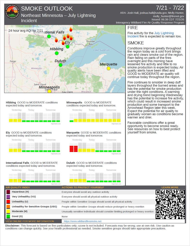
Combined acreage overall of the July Lightning Incident is 63,587 acres in the United States and an additional 8,412 acres in Canada. Estimated acreage of the Little Knife Fire is 4,598 acres. There are a total of 780 personnel on the July Lightning Incident. The public is being asked to support firefighters and public safety by adhering to all evacuations, closures, and fire restrictions; by refraining from flying drones, which endanger firefighting aircraft; and by keeping boats off the water in areas where water-gathering aircraft are operating. Fires reported on this update may change as some fires have merged or been moved into patrol status.
A Lutsen Township community informational meeting for the Little Knife Fire is planned for tonight (Tuesday, July 21) during the Lutsen Town Board Meeting at 7 PM. The meeting is open to the public and will be held at the Lutsen Town Hall (116 Caribou Trail). WTIP Radio will be live broadcasting and plans to livestream the meeting. The Superior National Forest Facebook page also intends to live stream the meeting.
Evacuations and Closures
Lake County: “GO” status for Hwy 16/Fernberg Corridor from the Garden Lake Bridge to the end of the Fernberg at Lake One due to the Camp Fire. Evacuate immediately.
St. Louis County: “GO” status was updated on July 18th for additional areas near the Echo Trail and “Ready” for the City of Winton north Burnside Lake. “GO” status for portions of the Echo Trail from Big Lake up to the 200 Road near the Sioux Fire. Other areas are under “SET” evacuation notice for Marian Creek, Ridge, Beaver Tail, Coffin & Echo 2 Fires
Cook County: “SET” status at the end of the Gunflint Trail due to the Little Knife Fire. The Midtrail area of the Gunflint Trail west of Hungry Jack Lake Rd. and the northern parts of the townships of Schroeder, Tofte, and Lutsen have moved into “READY” status.
Superior National Forest: has extended Boundary Waters Canoe Area Wilderness (BWCAW) Closure Order to protect public and firefighter health and safety through July 24. The BWCAW permit issuance and forest closure is being evaluated daily. Notifications are being made to permittees seven days prior to permit entry date.
Temporary Flight Restrictions are in place over certain portions of the fire area. Visit the Federal Aviation Administration (FAA) website for more information.
Fire Restrictions
Superior National Forest Forest-wide Fire Restrictions are also in effect.
Minnesota DNR updated fire restrictions are now in effect.
Weather and Fire Behavior
Cooler weather is expected today as mostly cloudy skies will limit the amount of sunlight we receive. Highs in the mid to upper 60s are forecast, keeping relative humidity values a bit higher than the previous two days at 46 to 54 percent. North-northwesterly winds will be strong this morning, with gusts of 19 to 26 miles per hour, but will gradually slow down late this afternoon. A 20% chance of light rain showers exists until about 1PM before skies begin to partially clear in the late afternoon.
Even with cooler temperatures, surface drying will increase with strong winds today and contribute to increased activity. With lower chances of precipitation today, expect to see fire danger indices and associated fire activity to begin increasing and building momentum. Areas where smoldering and creeping occurred over the last few days will begin to see a transition to surface fire. Pockets of pine and fir will begin to see isolated torching. The potential for initial attack response to holdover lightning fires exists. Stronger winds may hide smoke in the trees longer today, increasing the chance for fires to be well established before detection.
Operations
Non-Boundary Waters Canoe Area Wilderness Wildfires
- Camp: Approximately 4,402 acres. Location–5 miles north of Winton. Handcrews continued to build direct handline along the entire southern perimeter of the fire, connecting to Newton Lake on the east and other natural features on the west. Crews will continue to build and improve direct and indirect lines and structure protection along Fernberg Road, identifying structures and potential for contingency lines to the south and east out to Snowbank.
- Sioux: Approximately 12,354 acres. Location–North of the Echo Trail and east of Jeanette Campground. Portions of the fire are burning in BWCAW. Handcrews continue to work on establishing direct handline on the southern perimeter of the fire that crossed Echo Trail including digging handline and installing hoselays and a sprinkler system. This work with handcrews will continue today. Firefighters continue working further south from the immediate fire perimeter to develop a plan for additional indirect containment lines.
Boundary Waters Canoe Area Wilderness Wildfires - Little Knife: Originated in Ontario and crossed into the United States. The approximate fire acreage in the United States has been reduced to 4,598 acres due to more accurate mapping. Fire activity is currently minimal. Multiple reconnaissance flights have been conducted and a Chinook aircraft was used to strategically drop water on hot spots. Managed by the National Incident Management Organization (NIMO).
- Bear Trap (Bear Trap and Dark Fires combined): Approximately 37,747 total acres (29,682 acres in the United States). Location–South of Lac La Croix, 20 miles north of Ely. Structure protection with hose lays and sprinklers continued around the northern edge of Big Lake in Whispering Pines and Big Lake Lodge as well as private properties on the south side of the lake. Today, structure protection will continue around Big Lake as well as crews and equipment will begin clearing and widening the Echo Trail to the east to connect the Echo Trail to the Camp Fire and to the west towards the Sioux Fire.
- Thumb: 17,088 total acres (16,747 acres in the United States). Remote and located 6 miles south of Gakijiwanong Anishnaabe Nation Canada. The majority of fire activity was along the southwestern perimeter of the fire area, where the fire is backing down into natural barriers, close to the northern perimeter of the Sioux Fire. Aviation resources will monitor the fire during today’s operations
Wildfires West of Echo Lake and East of U.S. Hwy 53
The Chub Fire is the most active fire in this area. All the fires have firefighters and engines working on a variety of suppression tactics including building line, mopping up and patrolling and monitoring. There is a combined containment of 57% on these eleven fires. - Chub: 347.8 acres. 50% contained. Location – North of Chub Lake, southwest of Crane Lake. Crews will secure dozer line and handlines, followed by mop up and gridding to extinguish pockets of heat throughout the fire’s interior.
- 493: 0.7 acre. Location – South of Long Lake. Crews will secure dozer line and handlines, followed by mop up and gridding to extinguish pockets of heat throughout the fire’s interior.
- Echo 2: 16.5 acres. 100% contained. Location – off the Echo Rapids Road, north of Echo Lake. Crews will continue to patrol the fire, searching for smoke or hot spots and extinguishing any lingering heat.
- Beaver Tail: 11.6 acres. 100% contained. Location – West of the Vermilion River. Crews continue mop up, using hand tools and water to put out remaining pockets of heat, as they grid throughout the fire interior.
- Ridge: 8 acres. 100% contained. Location – East of the Vermilion River. Crews will continue to patrol the fire, searching for smoke or hot spots and extinguishing any lingering heat.
- Creek: 4.1 acres. 100% contained. Location – Crews will continue to patrol the fire and mop up, searching for smoke and hot spots and extinguishing any lingering heat.
- Marion Creek Trail: 12.2 acres. 100% contained. Location – West of the Vermilion River. Crews will continue to patrol the fire, searching for smoke and lingering heat.
- Nine: 5.4 acres. 100% contained. Location – South of Echo Lake. Crews will continue to patrol the fire, searching for smoke and any lingering heat.
- Camp 5/Duck: 4.0 acres, 100% contained (Camp Fire); 0.5 acres, 100% contained (Duck Fire). Location – North of Elephant Lake. Crews will continue to patrol the fire, searching for smoke and hot spots, then extinguishing any lingering heat
- Bug Creek: 0.1 acre. 100% contained. Crews continue to patrol the fire, searching for smoke and lingering heat.
- Coffin Fire: 0.1 acre. 100% contained. Crews will continue to patrol the fire, searching for smoke and any lingering heat.
History
On the evening of July 6, a dry thunderstorm moved across northeastern Minnesota and southern Canada resulting in more than 1,000 lightning strikes, causing dozens of fire starts. As unprecedented dry and warm conditions followed in the days after, fires were detected across Cook, Lake and St. Louis counties. Where fires were accessible by ground, firefighters were able to work to keep some of the fire perimeters small in size, however due to the number of fires, locations and number of firefighters and equipment, some of the fires continued to smolder and grow in the following days. Local fire managers ordered many additional resources including engines, hand crews, aviation resources and two incident management teams to support the firefighting efforts. While some of the fires were contained, several have continued to grow due to record breaking high temperatures and low humidity. Additional firefighters, equipment and support staff continue to be ordered including a Complex Incident Management Team.
Camp Fire (also known as Branch III) update
Monday, July 20, 2026 – 2:00 pm
Emergency Manager- Warren LaPlante
Wildfire Evacuation Guidance: Ready, Set, Go!
As fire conditions continue to change, residents should be prepared to act quickly. Know your evacuation status and take the appropriate steps below.
READY – Be Prepared
Residents in a Ready zone should begin preparing now.
- Create an evacuation plan and identify meeting locations and evacuation routes.
- Assemble an emergency kit with medications, important documents, pet supplies, clothing, and other essential items.
- Prepare your home by removing combustible materials around structures when it is safe to do so.
Stay informed by monitoring official updates and be prepared if your evacuation status changes.
SET – Be Ready to Leave
Residents in a Set zone should be prepared to evacuate at a moment’s notice.
- Pack your vehicle with essential belongings.
- Don’t forget the 6 P’s:
- People and Pets
- Papers (important documents)
- Prescriptions and medications
- Pictures and irreplaceable keepsakes
- Personal computers and important electronic data
- Plastics (credit cards) and cash
- Wear sturdy clothing and closed-toe shoes.
- Keep your vehicle fueled and backed into the driveway for a quick departure.
- If you feel unsafe, leave immediately– do not wait for an official evacuation order.
GO – Evacuate Immediately
Residents in a Go zone should leave immediately.
- Take your family, pets, medications, important documents, and emergency supplies.
- Follow designated evacuation routes and directions from emergency personnel.
- Close all windows, leave doors unlocked, and leave exterior lights on if power is available to help firefighters identify your home.
- Do not return to the area until evacuation orders have been lifted by local authorities.
Continue to monitor official updates from the Lake County Sheriff’s Office and emergency management officials for the latest information on evacuation zones, road closures, and fire conditions.
For continued updates, please visit the Lake County website.
FOREST SERVICE
U.S. Department of Agriculture
Minnesota Incident Command System
Superior National Forest & July Lightning Wildfires Facts Sheet, July 17, 2026, 12:00 pm
Inciweb: https://inciweb.wildfire.gov/incident-information/mnsuf-july-2026-superior-nf-wildfires
Facebook: https://www.facebook.com/SuperiorNF & https://www.facebook.com/mnics.org
Fire Information: 218-881-2091 (8:00 am–8:00 pm), 2026.JulyLightningEvent@firenet.gov
BWCAW Closures/Permittees: 218-235-4400 or 218-235-3113
Media Inquiries: 231-878-0998
Evacuations: Please contact county or local law enforcement officials for information on evacuations.
Superior National Forest | Evacuation Status
Lake County: Initiated the “GO” for Hwy 16/Fernberg Corridor from the Garden Lake Bridge to the end of the
Fernberg at Lake One due to the Camp Fire. Evacuate immediately. A temporary evacuation site has been
established at the Babbitt Municipal Building at 71 S Drive, Babbitt (hours may vary).
St. Louis County: Initiated “GO” for portions of the Echo Trail from Big Lake up to the 200 Road near the
Sioux Fire. Other areas are under “SET” evacuation notice for Marian Creek, Ridge, Beaver Tail, Coffin and
Echo 2 Fires
Cook County: Remains at “SET” status at the end of the Gunflint Trail due to the Little Knife Fire. The
Midtrail area of the Gunflint Trail west of Hungry Jack Lake Rd. and the northern parts of the townships of
Schroeder, Tofte, and Lutsen have moved into “READY” status.
Closures & Fire Restrictions
Superior National Forest has issued an Expanded BWCAW Closure Order to protect public and firefighter
health and safety. The BWCAW permit issuance is being evaluated daily with notifications to permittees 4-days
prior to permit entry date. Forest-wide fire restrictions are also in effect.
Key Messages
The forecast for erratic weather, shifting winds and the potential for isolated damaging wind gusts and
thunderstorms will be a challenge for firefighting efforts. Approximately 13,000 lightning strikes were detected
with the storms that moved through the area this morning. New fires may be detected as the sun comes out.
Before the rain, crews in some areas saw as many as five trees fall across the Echo Trail in the span of 1/2 hour.
Heavy smoke has impacted air operations, making it difficult to track the perimeter of some of these fires. Over
500 firefighters and support personnel are involved in these fires, with additional resources arriving daily. In
addition, over 16 state and local fire departments are involved in the firefighting efforts.
Wildfires
Currently, the forest has 16 active wildfires, with 3 active fires inside the BWCAW. Some fires have merged.
When that happens, the fire is given the name of one of the fires. This also changes the number of fires that are
reported here.
Non-Boundary Waters Canoe Area Wilderness wildfires
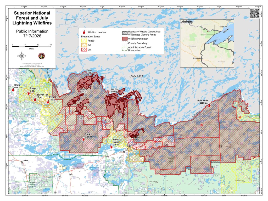
- Camp Fire started 7/7/2026. Size–2,886 acres. Location–5 miles north of Winton. Cause: Lightning.
Status: Extreme fire behavior and some growth yesterday and overnight. Evacuations in effect from this
fire. Firefighters are conducting structure protection and suppression with day and night shifts. - Sioux Fire started 7/9/2026. Size–approximately 7,368 acres. Location–North of the Echo Trail and east
of Jeanette Campground. Portions of the fire are burning in BWCAW. Extreme fire behavior and some
growth yesterday and overnight. Firefighters are utilizing structure protection, including around the
Meander Lake communication site and generator. The fire crossed Echo Trail near the Little Indian
Sioux River. Cause: Lightning. - Crescent Fire started 7/14/26. Size- .5 acre. Location- Island in Crescent Lake, Tofte. Human-caused.
Contained and will continue to monitor. - Birch Island (.25ac), Buck Fire (.1ac), are in patrol status.
Boundary Waters Canoe Area Wilderness wildfires - Little Knife started 7/15/2026. Size- estimated at 6,000 acres (US side). Smoke has hampered visibility
for mapping purposes. Location- heat detection mapping showed growth as far south as Ogishkemuncie
Lake. The fire has burned a total of 30,000 acres. - Bear Trap Fire started 7/7/2026. Total size of combined Bear Trap and Dark fires: Approximately
13,500 acres. Location–South of Lac La Croix, 20 miles N of Ely. Status–Extreme fire behavior with
crowning, torching and spotting. Fire crossed the international border and entered Canada and has
pushed to within 1/2 mile of the Echo Trail. - Thumb Fire started 7/7/2026. Size–14,129 acres. Location–remote & located 6 miles S of
Gakijiwanong Anishnaabe Nation Canada. Cause: Lightning. Status Remote with difficult access. Active
fire behavior. This fire has crossed the Canadian Border. Aircraft continue to suppress the fire on the US
side as conditions allow.
Minnesota Incident Command System managed wildfires - Echo 2 Fire started 7/8/2026. Size – 16.4 acres. Location – off the Echo Rapids Road, north of Echo
Lake. Moderate fire activity yesterday. Firefighters will continue to improve containment lines and
search for and extinguish any found heat. - Chub Fire started 7/9/2026. Size – 337 acres. Location – North of Chub Lake, southwest of Crane
Lake. The fire was less active yesterday and crews utilized a dozer to establish control and contingency
lines. Today firefighters will continue to improve dozer lines and handlines around the fire’s perimeter. - Beaver Tail started 7/9/2026. Size – 12 acres. Location – West of the Vermilion River. Low to moderate
fire activity yesterday. A control line has been established along the entire perimeter of the fire. Crews
will search for and extinguish any found heat. - Ridge Fire started 7/9/2026. Size – 8 acres. Location – East of the Vermilion River. Minimal fire
behavior yesterday. Crews will continue to reinforce and improve containment and control lines around
the fire and cool any hot spots found. - Creek Fire started 7/9/2026. Size – 4 acres. Location – Northwest of Chub Lake. Minimal fire activity
yesterday. Firefighters continue to strengthen and improve control lines with crews and equipment.
2 - Marion Creek started 7/9/2026. Size – 16 acres. Location – West of the Vermilion River. No significant
fire activity yesterday. Crews established dozer line around the fire. Today, firefighters will work to
improve the control lines and install hose lines. - Nine Fire started 7/9/2026. Size – 5.4 acres. Location – South of Echo Lake. Minimal fire activity
yesterday. Firefighters continue to mop up and to search for an extinguish any found heat. - Camp 5/Duck Fire started 7/9/2026. Size – 4 acres. Location – North of Elephant Lake. Minimal to no
fire activity was detected. A dozer will work to improve control lines around the Camp 5 Fire today. - Bug Creek & Coffin Fires started 7/9/2026. Size – 0.2 acre. Aircraft and firefighters continue to verify
the fires remain secure by checking for smoke and remaining heat.
Canadian managed wildfires - Canada is experiencing similar fire activity. Multiple fires have crossed the International Border. The
forest is coordinating with Canadian fire officials. Ontario Wildfire Information.
Background
On the evening of July 6, 2026, a storm system moved through the area with lightning and little precipitation.
The following day, several small wildfires were reported. Local and off‑forest firefighting resources are
conducting suppression on these fires. With warm and dry summer conditions, additional wildfires are being
detected daily.
National Weather Service Forecast
Stormy conditions are expected today with a high likelihood of showers and thunderstorms. There is the
potential for isolated damaging wind gusts associated with the stronger storms along with localized heavy rain.
Rain amounts of 0.25 to 0.50 inches are expected with isolated higher amounts where thunderstorms persist.
Winds during the morning are expected to be from the southeast then switch to the northwest between
1300-1500 with the passage of a cold front with gusts of 15 to 20 mph.
Safety Messages
Flying drones or other aircraft over the fire is prohibited. If non-authorized aircraft are detected near the fire,
any air operations supporting the fire will stop. Drones are illegal in federally designated wilderness areas and
compromise the safety of firefighters and hinder fire operations. Recreational boaters and property owners on
waterways where aircraft are water-gathering are urged to remain on the shoreline. Watercraft idling in wide
bays will force emergency aircraft to abort their mission.
Camp Fire update
Thursday, July 16, 2026 – 4:00 p.m.
Emergency Manager- Warren LaPlante
The temporary evacuation point at the Babbitt Municipal Building, 71 South Drive, Babbitt, MN, will close at 9:00 p.m. on Thursday, July 16. The evacuation point will remain closed unless additional needs arise.
Air quality is hazardous for everyone throughout Lake County on 7/16/2026. It’s expected to remain unhealthy through at least July 17, 2026. Monitor changes to air quality via local news or by visiting www.airnow.gov. Protect your health by avoiding outdoor activities, shutting windows and doors and using air purifiers or air conditioners set to recirculate. If you must be outside, consider using an N95 mask. For people at higher risk due to medical conditions or other factors, N95 masks are available at the Lake County Service Center, 616 3rd Ave., Two Harbors during regular business hours, 8:00 a.m. to 4:00 p.m. Monday through Friday.
Camp Fire update
Wednesday, July 15, 2026 – 4:30 p.m.
Emergency Manager- Warren LaPlante
FOR IMMEDIATE RELEASE
Additional “GO!” evacuation notifications will now be displayed across the Boundary Waters Canoe Area Wilderness (BWCAW) in Cook, Lake, and St. Louis counties to align with the Boundary Waters Canoe Area Wilderness Closure, which was updated on July 13, 2026. This change ensures consistency between the National Forest System lands and county evacuation messaging. It does not affect any additional residences or private property.
Fire managers, the USDA Forest Service, the Minnesota Department of Natural Resources, and officials from Cook, Lake, and St. Louis counties continue to meet regularly to assess fire conditions and coordinate response efforts. These meetings help ensure that advance notice can be provided to the public if changes to Ready, Set, Go evacuation statuses become necessary.
As part of the response to the Camp Fire, Lake County established a temporary evacuation point at the Babbitt Municipal Building, 71 South Drive, Babbitt, Minnesota, on July 14, 2026. Public Health staff from Lake County and St. Louis County have been jointly staffing the facility each day from 8:00 a.m. to 9:00 p.m.
The temporary evacuation point will remain open on Thursday, July 16. Any residents impacted by the fire, heat or poor air quality are welcome to utilize the facility during operating hours.
Camp Fire update
Tuesday, July 14, 2026 – 5:00 p.m.
Emergency Manager- Warren LaPlante
Public Information Update – Evacuation Resources
The temporary evacuation point at the Babbitt Municipal Center will remain open until 9:00 p.m. today and will reopen Wednesday, July 15, at 8:00 a.m.
Sheltering:
There are no public shelters available at this time.
Pet Assistance:
The Ely Veterinary Clinic has travel kennels available to borrow for anyone needing a safe way to transport pets during the fire evacuations. Residents may stop by the clinic to borrow a kennel.
For those who need emergency pet boarding, Pup North in Eveleth has generously offered assistance. Please call 218-744-1477 for boarding arrangements.
Donations:
At this time, no donations have been identified as needed for evacuees. If needs arise, additional information will be shared through official county communication channels.
Residents are encouraged to continue monitoring Lake County’s website and official county communication channels for the latest updates.
Camp Fire update
Tuesday, July 14, 2026 – 11:00 a.m.
Emergency Manager- Warren LaPlante
Amended Evacuation Notice
The Lake County Sheriff’s Office, in coordination with the U.S. Forest Service, is issuing an expansion to the evacuation zone, which will now include the area in between Fall Lake and Cedar Lake. The zone is titled “North Fall Lake – 2A” on the evacuation zone map located on the Lake County website.
The evacuation status for this area has been elevated to GO. Residents and visitors should leave immediately.
The evacuation still includes all adjoining roads, driveways, and trails from Lake One and Snowbank Lake to the Garden Lake Bridge.
Before leaving, bring:
- Prescription medications
- Important documents
- Credit cards and cash
- Pets and necessary pet supplies
The Lake County Sheriff’s Office will conduct door-to-door notifications throughout the GO evacuation zone. Residents are urged to remain alert to changing conditions and follow all evacuation orders and instructions from local officials.
Temporary Evacuation Point
A Temporary Evacuation Point opened at 8:30 a.m. at:
Babbitt Municipal Building
71 South Dr.
Babbitt, MN 55706
The site will be staffed throughout the day. Anyone who anticipates needing overnight shelter is encouraged to check in as early as possible.
Evacuation Zone Map
An interactive evacuation map is available on the Lake County website.
To view the map:
- Visit the Lake County website.
- Select “Lake County Mapping and Online Parcel Mapping.”
- Open the map and select the “Fire Evacuation” tab in the lower-right corner.
Direct map link: https://experience.arcgis.com/experience/10688a627618414fa96159e8f70cba3c/page/Fire-Evacuation
Ongoing Response
The U.S. Forest Service continues to monitor the Camp Fire and is working closely with the Lake County Sheriff’s Office, Emergency Management, and other responding agencies to assess fire behavior and coordinate response efforts.
Residents and visitors should continue to monitor official updates for the latest information on fire conditions, evacuation zones, road closures, and public safety guidance.
For continued updates, please visit the Lake County website.
Camp Fire Update
Monday, July 14, 2026 – 6:00 a.m.
Emergency Manager: Warren LaPlante
Immediate Evacuation Notice
The Lake County Sheriff’s Office, in coordination with the U.S. Forest Service, is issuing an IMMEDIATE EVACUATION for the Fernberg Road Corridor beginning at 7:00 a.m. on Tuesday, July 14, 2026.
The evacuation includes all adjoining roads, driveways, and trails from Lake One and Snowbank Lake to the Garden Lake Bridge.
The evacuation status for this area has been elevated to GO. Residents and visitors should leave immediately.
Before leaving, bring:
- Prescription medications
- Important documents
- Credit cards and cash
- Pets and necessary pet supplies
The Lake County Sheriff’s Office will conduct door-to-door notifications throughout the GO evacuation zone. Residents are urged to remain alert to changing conditions and follow all evacuation orders and instructions from local officials.
Temporary Evacuation Point
A Temporary Evacuation Point will open at 8:30 a.m. at:
Babbitt Municipal Building
71 South Dr.
Babbitt, MN 55706
The site will be staffed throughout the day. Anyone who anticipates needing overnight shelter is encouraged to check in as early as possible.
Additional Evacuation Zone Changes
Evacuation levels have changed in other areas as well. Residents and visitors should check the Lake County website regularly for the most current evacuation zones and public safety information.
These changes are based on forecasted weather conditions that could result in rapid wildfire growth, heavy smoke, reduced visibility, and hazardous air quality.
Evacuation Zone Map
An interactive evacuation map is available on the Lake County website.
To view the map:
- Visit the Lake County website.
- Select “Lake County Mapping and Online Parcel Mapping.”
- Open the map and select the “Fire Evacuation” tab in the lower-right corner.
Direct map link: https://experience.arcgis.com/experience/10688a627618414fa96159e8f70cba3c/page/Fire-Evacuation
Ongoing Response
The U.S. Forest Service continues to monitor the Camp Fire and is working closely with the Lake County Sheriff’s Office, Emergency Management, and other responding agencies to assess fire behavior and coordinate response efforts.
Residents and visitors should continue to monitor official updates for the latest information on fire conditions, evacuation zones, road closures, and public safety guidance.
For continued updates, please visit the Lake County website.
Camp Fire update
Monday, July 13, 2026 – 5:00 PM
Emergency Manager- Warren LaPlante
Camp Fire in Superior National Forest Becomes Active; Evacuation Zones Implemented
The Camp Fire, located in the Superior National Forest, has become active and is currently burning in a northeast direction. The fire is being closely monitored by the U.S. Forest Service and other responding agencies as crews work to assess conditions and support public safety efforts.
The Camp Fire was first reported on July 7, 2026, and initially burned approximately 1.6 acres. The fire began approximately 8 miles north/northeast of the Cloquet Line, outside the Boundary Waters Canoe Area Wilderness (BWCAW). The cause of the fire has been determined to be lightning.
The fire has reignited, and due to increased fire activity, the Lake County Sheriff’s Office, in coordination with the U.S. Forest Service and other emergency responders, has implemented the Ready, Set, Go! notification plan. Evacuation zones have been established and updated based on current fire conditions and the potential risk to nearby areas.
The Lake County Sheriff’s Office has been actively working in the affected area and conducted door-to-door notifications within the “Go” evacuation zone. Residents are encouraged to remain aware of changing conditions and follow all evacuation notifications and instructions from local officials.
An evacuation zone map is available on the Lake County website. To access the map:
- Visit the Lake County website.
- Select “Lake County Mapping and Online Parcel Mapping” from the main page.
- Open the map and select the “Fire Evacuation” tab located in the bottom-right corner.
The U.S. Forest Service is actively monitoring the Camp Fire and coordinating with Lake County officials and other responders to evaluate fire behavior and determine appropriate response actions.
Residents and visitors are encouraged to continue monitoring official updates from Lake County and emergency management officials for the latest information regarding fire conditions, evacuation zones, and public safety guidance.
For continued updates, please visit the Lake County website.