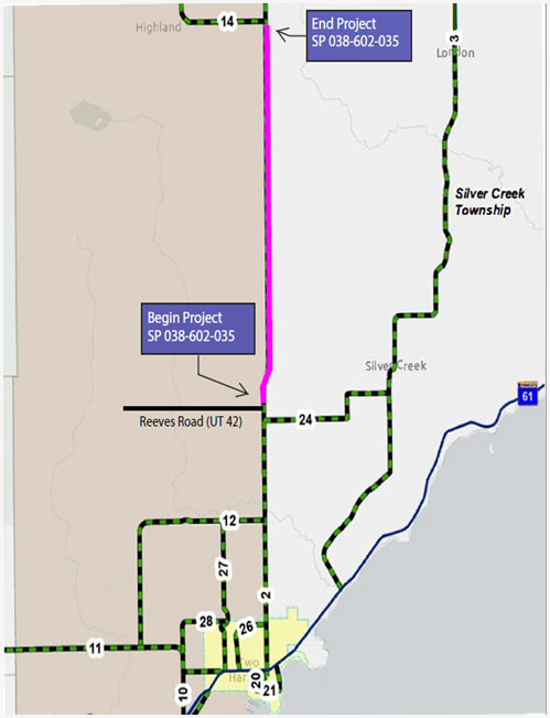
Pavement Resurfacing on Highway 2 (CSAH 2) between Reeves Road and Wales Road (CSAH 14) is scheduled to begin Monday, September 28.
Traffic Impacts Highway 2 will remain open to traffic but will be restricted to one lane within the work zone with traffic flagging operations. Expect delays up to 10 minutes.
Work Scope Hawkinson Construction will be milling off the pavement surface layer and resurfacing the road.
Duration Milling and paving is anticipated to take approximately 2 weeks. Shouldering, signing and pavement marking will follow, with all work expected to be completed by mid to late October.
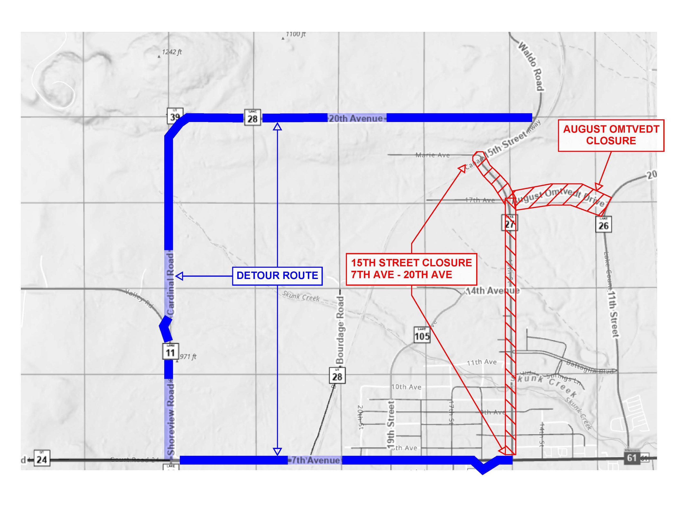
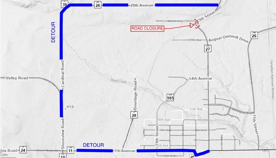
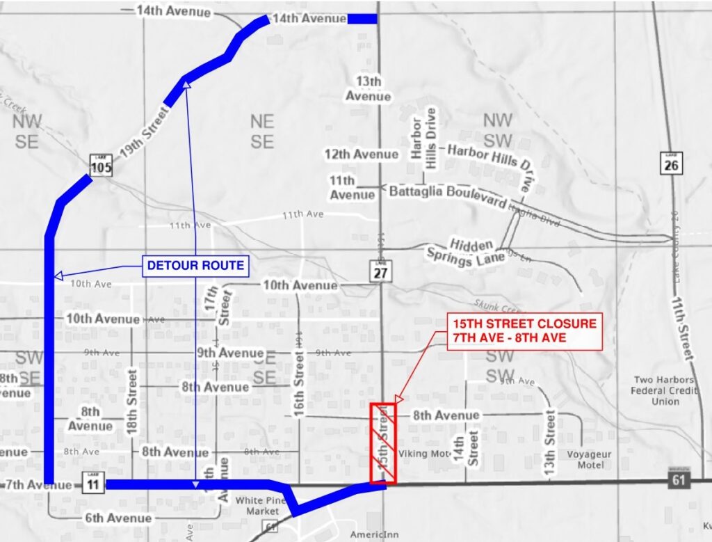
NOTICE 15th Street (CSAH 27) in the City of Two Harbors will be closed to through traffic between 7th Avenue (Hwy 61) and 20th Avenue (CSAH 28). August Omtvedt Blvd will be closed to through traffic between 15th Street and 11th Street (CSAH 26)
When Beginning: Week of September 21 Ending: November 6, 2026
Purpose Lake County’s contractor, KGM Contractors will be repairing and reconstructing stormwater drainage structures and resurfacing the street.
Traffic Impacts A detour route will be posted on 7th Avenue (CSAH 11), Shoreview Road (CSAH 11), Cardinal Road (CSAH 28) and 20th Avenue (CSAH 28). August Omtvedt Blvd will not be closed until later in the project schedule and may be used as an alternate route until it is closed.
Property Access 15th Street will remain open to residents and property owners at all times; access to 15th Street will be available via Battaglia Blvd, 9th Avenue or 14th Avenue. Driveway access will remain open, except when impacted by adjacent paving or pavement removals; access restrictions are anticipated to last less than an hour each occurrence. Some driveway aprons will require repair or replacement, and additional access limitations may be necessary. Project personnel will be in contact with affected property owners.
New Tomahawk Road will not open by September 19th as originally scheduled. Delays related to material suppliers will extend the closure until the week of September 21st. I anticipate that Lake County’s contractor will be able to get the road open by the middle to end of the week.
Lake County and Lake County’s contractor have been coordinating project schedules with MnDOT and MnDOT’s contractor related to the scheduled closure of Hwy 1 and planned use of the New Tomahawk Road as a detour for Hwy 1. Both roads will not be closed at the same time. We anticipate the Hwy 1 closure will be in place with the detour signed on New Tomahawk Road the same day or day following the opening of New Tomahawk Road.
The posted ATV detour will be removed shortly after opening the New Tomahawk Road.
Property tax payments are due May 15 and October 15.
New for 2026: Check out our platform for online payments and credit card transactions via the QR Code below (Current year tax statements may also be found there)
Taxes can be paid in person, by mail, drop box or online.
Notice is hereby given that the Lake County Board of Commissioners will hold a Public Hearing on Tuesday, August 25, 2026, at 2:30 P.M. at the Lake County Service Center, Split Rock River Room, 616 Third Avenue, Two Harbors, Minnesota, 55616.
The purpose of the public hearing is to receive comments on a proposed Ordinance. The purpose and intent of the proposed Ordinance is to regulate camping and land use on County Administered Lands.
Summary of the proposed ordinance:
The proposed Lake County Ordinance would regulate camping and other uses of County Administered Lands, including County tax-forfeited and County-owned properties.
The proposed ordinance establishes limits on camping on County Administered Lands. Camping would generally be limited to fourteen (14) days at one camp location from the first Saturday in May through the second Sunday in September, and twenty-one (21) days during the remainder of the year. A subsequent camp location within the same calendar year would be required to be at least fifteen (15) miles from any prior camp location.
The ordinance would prohibit certain activities on County Administered Lands, including camping within one mile of a fee campground; digging or trenching around shelters; constructing permanent shelters; placing wood, nails, screws, or other fasteners in living trees; littering; and improperly disposing of human waste, sewage, or other wastewater. The ordinance would also prohibit cutting, removing, or carrying away timber without authorization.
The proposed ordinance would establish requirements for campfires, including restrictions during red flag warnings or campfire bans, requirements for safe placement and maintenance of fires, a maximum campfire size of three feet by three feet, and requirements that campfires be attended and completely extinguished before being left unattended.
The ordinance would prohibit the abandonment of personal property and motor vehicles on County Administered Lands, subject to limited exceptions for property and vehicles temporarily associated with active camping. Abandoned property and vehicles may be handled in accordance with applicable Minnesota law.
The ordinance would also prohibit land use that is contrary to the ordinance or posted restrictions, including posted “No Trespassing” notices, and would address public nuisances occurring on County Administered Lands.
A draft of the proposed ordinance is available at the Lake County Service Center, Office of the County Administrator, 616 Third Avenue, Two Harbors, Minnesota, 55616. All persons interested are invited to attend the Public Hearing. Written comments may be submitted to clerk.board@lakecountymn.gov or by U.S. Postal Service mail to Lake County Service Center, Office of the County Administrator, 616 Third Avenue, Two Harbors, Minnesota, 55616
Notice is hereby given that the Lake County Planning Commission will conduct an environmental review on behalf of, and authorized by, the Lake County Board of Commissioners on August 17, 2026, at 6:15 p.m. in the Split Rock River Conference Room of the Lake County Service Center, 616 3rd Ave, Two Harbors, MN 55616. The hearing will also be available to view via Microsoft Teams at the following link: https://teams.microsoft.com/meet/272988895347173?p=Xm5Czb5JZDMrOryiMe
The Planning Commission will review the prepared Environmental Assessment Worksheet (EAW) and the comments received during the required 30-day public comment period. In accordance with Article 4 of Lake County Environmental Review Ordinance #8, a recommendation will be made to the County Board on whether it should require the preparation of an Environmental Impact Statement.
The EAW was submitted by Silver Rapids Resort, LLC, for the expansion of the existing Silver Rapids Resort and conversion to a planned unit development at 459 Kawishiwi Trail, Ely, MN 55731. The property is legally described as: Parcel One: Government Lot Three (3), except the westerly four hundred feet (400′) thereof, Section Thirty-two (32), Township Sixty-three (63), Range (11); Parcel Two: Part of Government Lot Five (5), Section Twenty-nine (29), Township Sixty-three (63), Range Eleven (11), LESS and EXCEPT that portion thereof described as follows: Assuming the south boundary of said Lot 5 to lie due east and west, and beginning at an iron pipe which is the SW corner of said Lot 5, run North 01 degrees 08 minutes 30 seconds East along the west boundary of said Lot 5 a distance of 406.00 feet to an iron pin; thence South 82 degrees 55 minutes 42 seconds East a distance of 430.91 feet to an iron pin; thence South 07 degrees 14 minutes 54 seconds East a distance of 355.72 feet to an iron pin which lies on said south boundary; thence due west along said boundary a distance of 480.22 feet back to the iron pipe which is the point of beginning. 48.47 acres, zoned shoreland RR/Residential-Recreational (Resort) on Farm/White Iron Lake, Fall Lake. PID: 28-6311-29850/32070.
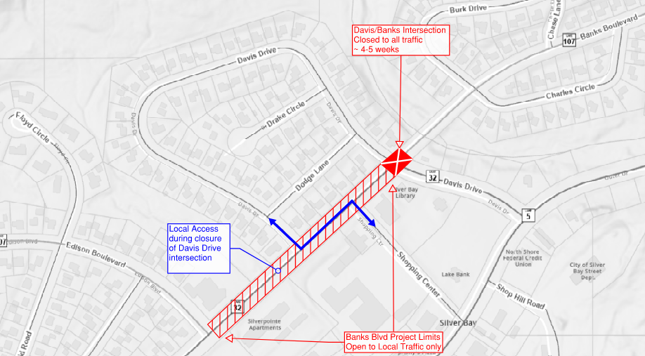
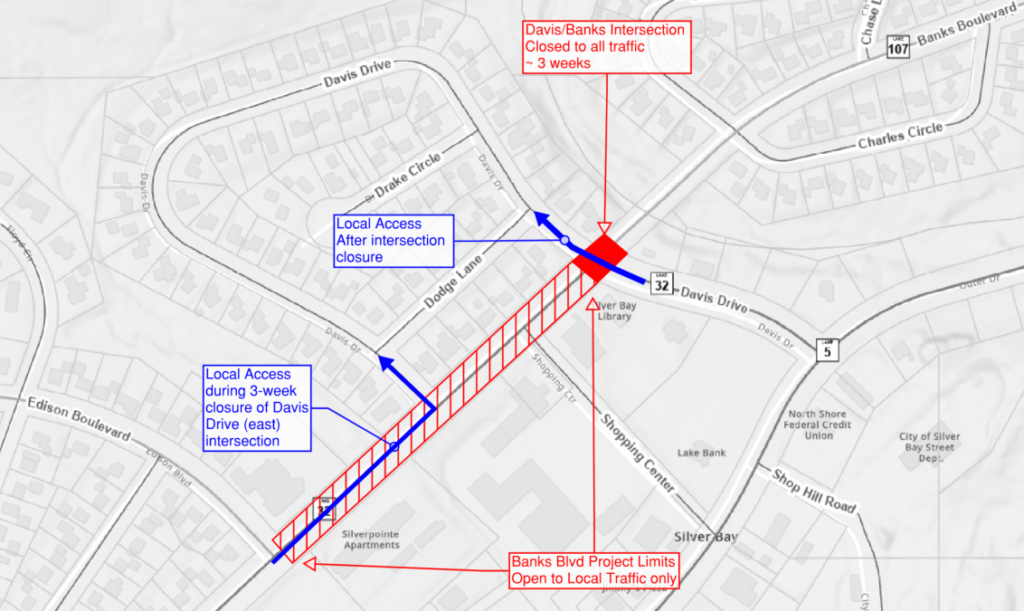
NOTICE Traffic operations for the Banks Boulevard reconstruction project in Silver Bay will change beginning Monday, August 10.
Davis Drive: Closed to all traffic at Banks Blvd intersection (east intersection)
Closure duration: 4-5 weeks
Access to city hall/police station/library from Outer Drive via Shopping Center Drive and Davis Drive
**Access for residents on Davis Drive/Drake Cir via Shopping Center Drive to Banks Blvd and west Davis Drive intersection**
Access for residents east of Davis Drive via Adams Blvd
Banks Blvd:
Remains closed to through traffic
**Local traffic access between Edison Blvd and Davis Drive (west)**
Fire station access always maintained
**Banks Blvd will remain an active construction zone reduced travel width and gravel surfacing. Please travel cautiously through the work area and beware of crews and equipment working to complete concrete pours and final restoration work.**
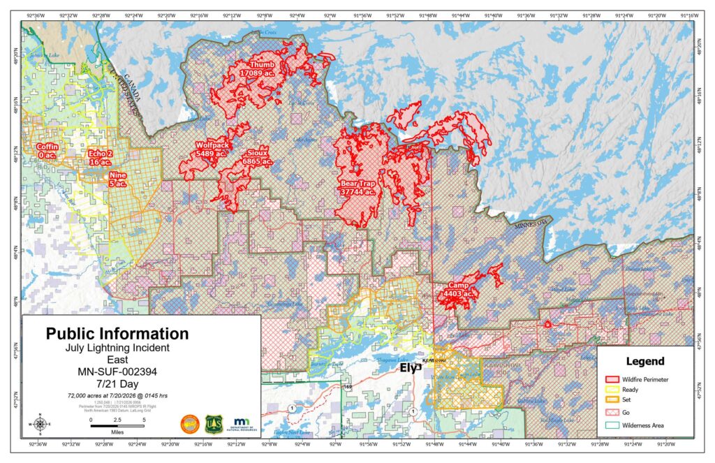
After careful consideration of current fire conditions, firefighter operations, and the ongoing assessment of the Camp Fire, Lake County officials have determined that one evacuation zone change will take effect at 5 p.m. today.
The designated area of North Fall Lake 1A will be removed from SET status and will return to normal status, with no evacuation restrictions in place.
While these changes reflect current conditions, the Camp Fire remains active, and conditions can change rapidly. Residents in these areas should remain prepared to evacuate if conditions worsen.
The Evacuation Zone Map will be updated to reflect these changes at 5:00 p.m. Residents are encouraged to continue monitoring official Lake County communications for additional updates.
Firefighters and other emergency personnel remain actively engaged in operations throughout the affected areas. Residents and visitors are asked to remain alert and use caution near ongoing firefighting operations.
For additional information and the latest evacuation information, visit the Lake County website at https://lakecountymn.gov.
Camp Fire (also known as Branch III) update
Wednesday, August 12, 2026
Emergency Manager- Warren LaPlante
Evacuation Status Changes – Fernberg Corridor & Surrounding Lake County Areas
After careful consideration of current fire conditions, firefighter operations, and the ongoing assessment of the Camp Fire, Lake County officials have determined that several evacuation zone changes will take effect at 7:00 p.m. Wednesday, August 12.
Effective at 7:00 p.m.:
Evacuation zone North Fall Lake 1A, directly surrounding the area where the Camp Fire originated will change from GO to SET.
The Fernberg Corridor, the White Iron Chain of Lakes, and the other four North Fall Lake zones will have all evacuation levels removed.
While these changes reflect current conditions, the Camp Fire remains active, and conditions can change rapidly. Residents in these areas should remain prepared to evacuate if conditions worsen.
The Evacuation Zone Map will be updated to reflect these changes at 7:00 p.m. Residents are encouraged to continue monitoring official Lake County communications for additional updates.
Firefighters and other emergency personnel remain actively engaged in operations throughout the affected areas. Residents and visitors are asked to remain alert and use caution near ongoing firefighting operations.
For additional information and the latest evacuation information, visit the Lake County website at https://lakecountymn.gov.
Camp Fire (also known as Branch III) update
Wednesday, July 29, 2026
Emergency Manager- Warren LaPlante
Evacuation Zone Status Update
Fire response operations along with recent rains helped modify fire activity on the July Lightning Incident fires. After careful consideration, Lake County, in close consideration with the Incident Command Team, has further reduced evacuation zone areas that have been in effect. The following changes will be effective at 7:00 PM tonight, July 29, 2026:
Zones North Fall Lake 2B, South Fall Lake, East and West Winton, Ojibway Lake, Moose Lake, and Snowbank Lake will be downgraded from a SET status to a READY status.
Zones North Fall Lake 1B and 2A will remain in SET status.
Zones North Fall Lake 2C, West Winton A, and North and South Silver Rapids will remain in READY status.
It is important to note that, despite these changes, the fire danger across Northern Minnesota is still moderate to high. Recent storms produced a significant amount of lightning, but precipitation was not consistent across the region. The public is encouraged to continue to use caution when visiting these areas and be prepared for the READY-SET-GO status to change as weather and fuel conditions evolve.
Emergency personnel and fire crews remain actively working throughout the incident area. Motorists and visitors are asked to use extra caution, watch for emergency vehicles and equipment on roadways, and give responders plenty of space to work safely.
For continued updates, please visit the Lake County website
Camp Fire (Branch III of the July Fire Incident) Update Tuesday, July 28, 2026 Emergency Manager- Warren LaPlante
Evacuation Status Update – North Cedar Lake Area and Cloquet Line Road
Effective at 7:00 p.m. on Tuesday, July 28, the following evacuation status changes and road updates are in effect for the North Cedar Lake area and Cloquet Line Road in Lake County:
The area Northof Cedar Lake to the Cloquet Line Road that is currently under GO evacuation status is being downgraded to SET.
Cloquet Line Road, from the boat launch to the St. Louis County line, is now open to local traffic.
If you must travel through this area, please use caution. Firefighters and other emergency personnel remain actively working throughout the area. Fire suppression operations, patrols, and monitoring continue, and your patience and cooperation are essential to keeping everyone safe.
Please continue to monitor official updates and be prepared to leave immediately if evacuation conditions change.
July Lightning Incident/Little Knife Fire Daily Update July 27, 2026
**A community meeting about the July Lightning Incident will be held tonight at 6 pm at the Ely Memorial High School Auditorium at 600 E Harvey Street, Ely, MN. An operational briefing about the fires will be presented and a live virtual option will be available on the Superior National Forest’s Facebook page (facebook.com/SuperiorNF). If you have a question you would like addressed, please email 2026.JulyLightningEvent@firenet.gov and write “Community Meeting Questions” in the subject line.
Summary
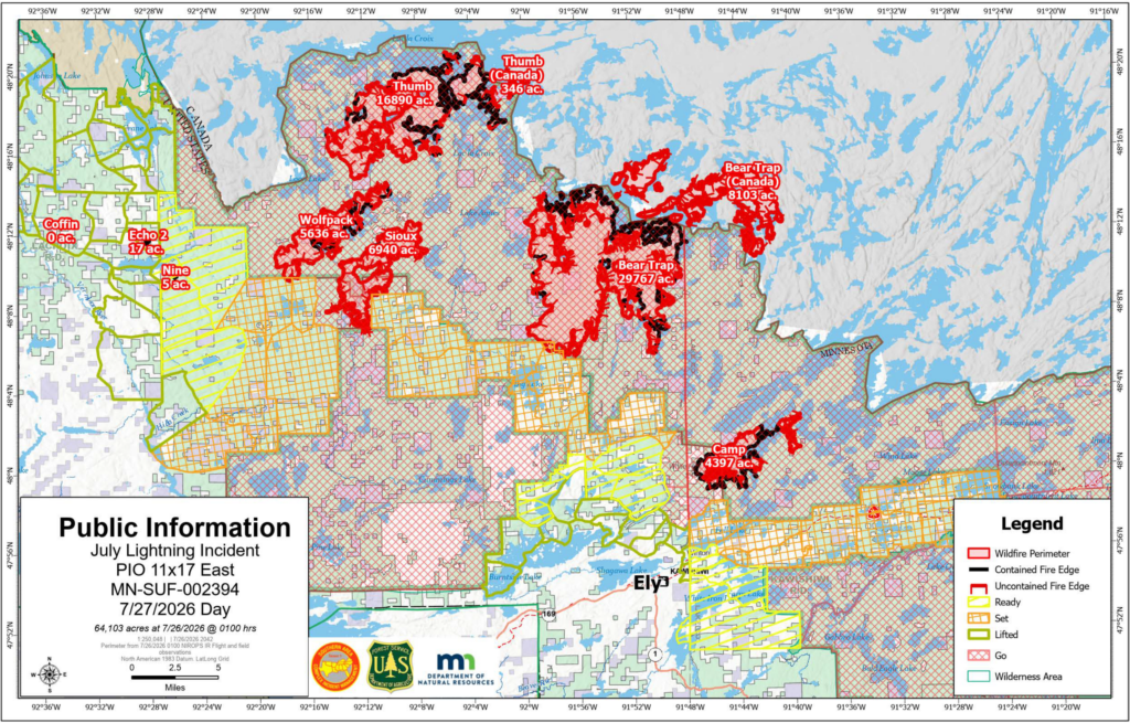
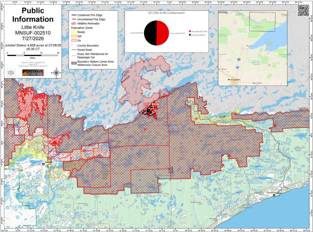
Overall combined acreage of the July Lightning Incident is 64,103 acres in the United States and an additional 8,443 acres in Canada. Estimated acreage of the Little Knife Fire is 4,958 acres. There is a total of 1,066 personnel on the July Lightning Incident and a total of 125 personnel on the Little Knife Fire. Containment estimates continue to fluctuate based on current fire behavior, fuels, weather and using natural barriers like lakes and waterways for containment perimeters. The public can support firefighters and their safety by adhering to all evacuations, closures, and fire restrictions; by refraining from flying drones, which endanger firefighting aircraft; and by keeping boats off the water in areas where water-gathering aircraft are operating.
Evacuations and Closures
An interactive map is available for residents and property owners to determine evacuation levels for their property. Residents and property owners can search this map by address to determine exact locations and evacuation levels. Click on the county name below for county-specific information.
Lake County: Most evacuations were downgraded on the evening of Sunday, July 26. Areas that were in “GO” status are now in “SET”. Areas that were in “SET” status are now in “READY”. North Fall Lake 1, located adjacent to the fire area, remains in “GO” status. A road closure will be in place at the Cedar Lake Boat Access and no traffic will be allowed beyond that point. Please view the Lake County evacuation zone map for more specific information.
St. Louis County: Most evacuations were downgraded on the evening of Sunday, July 26. Zones 200 and 201 along the Cloquet Line and Zone 100 along the Echo Trail will remain in “GO” status. All other evacuation zones currently in “GO” status will be downgraded to “SET”. All evacuation zones that had been “SET” are now in “READY” status. The entire Echo Trail will close daily between 9:30 am and 7 pm to protect the safety of firefighters and equipment still working. Please view the St. Louis County evacuation zone map for more specific information.
Cook County: Effective today, Monday July 27, “READY” status in Gunflint Districts two, three and four is removed. Gunflint District 1 is downgraded from “SET” to “READY”. The BWCA East district at “GO” will be removed and the BWCA West district at “GO” will be updated to follow the Forest Service map of the BWCA in Cook County that is open for daytrips starting Monday.
Superior National Forest: Forest Officials announced on July 24 that a Proposed Phase 2 plan – could be implemented this week barring no significant wildfire activity over this weekend. The proposed Phase 2 Plan would open select entry points on the eastern side of the Boundary Waters Canoe Area Wilderness (BWCAW) to overnight use. The Forest announced Phase 1 earlier this week that select BWCAW entry points will open to the public for ‘Day Use’ starting today, on the Gunflint and Tofte Districts (Eastern side of the forest), and BWCAW Overnight permits were cancelled through July 29, 2026. Daily, the Forest Service continues to evaluate the affected BWCAW quota permit entry point areas and other recreation areas outside the BWCAW in an effort to reopen select areas (as fire activity, weather and resources allows). A BWCAWClosure Order is in place to protect public and firefighter health and safety. The public is encouraged to monitor the forest’s Alerts webpage and recreation webpage for open and closed areas.
Temporary Flight Restrictions are in place over certain portions of the fire area. Reminder, there is a permanent flight restriction over the BWCAW. Visit the Federal Aviation Administration (FAA) website for more information.
Temperatures will continue to remain above normal the next few days as a portion of large-scale heat dome currently over the western US moves east over the fire area. Meanwhile, the jetstream will pass through the Upper Midwest as it rounds the periphery of the heat dome. This jetstream will periodically bring atmospheric disturbances into our region and give daily chances for showers and thunderstorms, mainly during the afternoon and evening.
Rain has moderated surface fire activity, but heat still remains in the duff below the surface.
Operations
Non-Boundary Waters Canoe Area Wilderness Wildfires
Camp: Approximately4,407 acres. 39% contained. Location – 5 miles north of Winton. Yesterday, crews mopped up along the southwestern flank of the fire and assessed structures on the Cloquet Line. Today crews will scout and plan for opportunities to construct fireline on the southeastern side of the fire and continue brushing along the Cloquet Line.
Sioux: Approximately 12,615 acres. 27% contained. Location – North of the Echo Trail and east of Jeanette Campground. Portions of the fire are burning in BWCAW. Yesterday, crews continued extensive mop up south of Echo Trail. Today, crews will widen the fuel break on Echo Trail to at least 100 feet. Structure protection continues in the Moose Loop and Meander Lake areas.
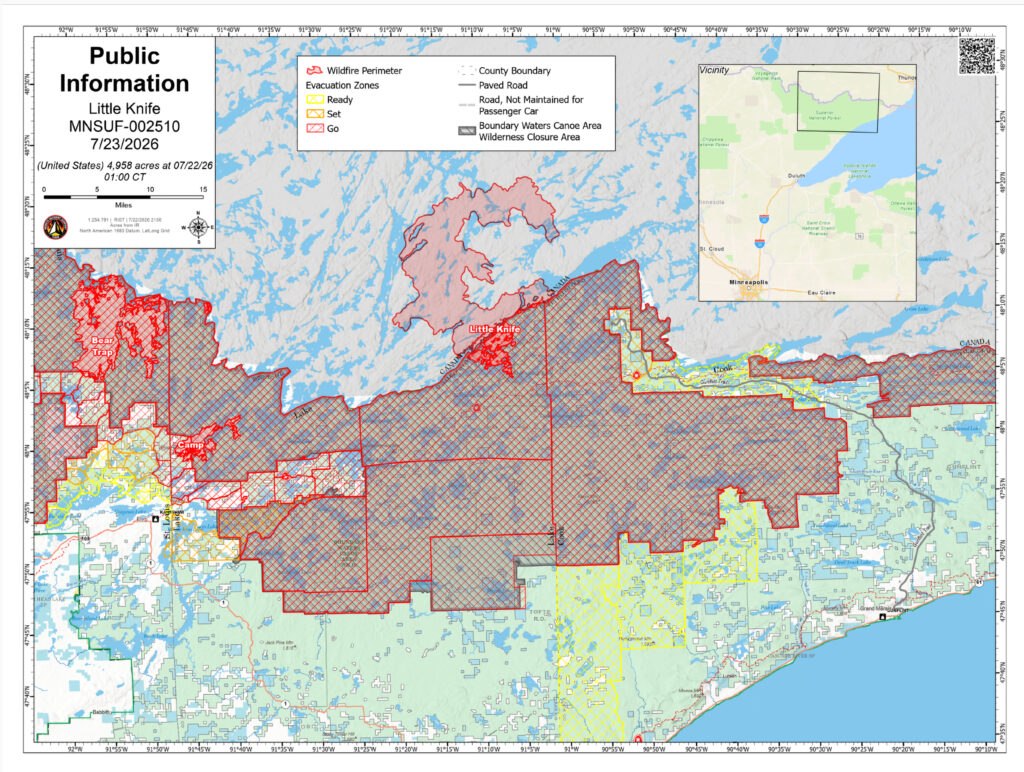
Little Knife: Originated in Ontario and crossed into the United States. Approximately 4,958 acres. 49% contained. A hotshot crew continues to work the eastern perimeter, traveling by canoe to improve portages as control features between lakes. 12 smokejumpers and two specialized wildland fire modules were also deployed to the southwestern and eastern sides of the fire. No significant fire behavior is expected today, however heat remains in the duff beneath the surface. Managed by the National Incident Management Organization (NIMO).
Bear Trap (Bear Trap and Dark Fires combined): Approximately 37,837 total acres (29,767 acres in the United States). 38% contained. Location – South of Lac La Croix, 20 miles north of Ely. Yesterday, crews made progress widening the fuel break on Echo Trail to at least 100 feet. Chipping around structures at Big Lake continues today and masticators are brushing along Angleworm trail.
Thumb: 17,236 total acres (16,890 acres in the United States). 56% contained. Remote and located 6 miles south of Gakijiwanong Anishnaabe Nation Canada. Yesterday, a hotshot crew demobilized from the fire via watercraft and today the fire will be unstaffed.
Wildfires West of Echo Lake and East of U.S. Hwy 53
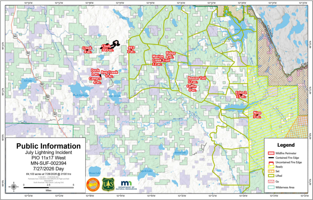
Chub: 344 acres. 95% contained. Location – North of Chub Lake, southwest of Crane Lake. Crews will continue with mop up to extinguish pockets of heat throughout the fire.
493, Echo 2, Beaver Tail, Ridge, Creek, Marion Creek Trail, Nine, Camp 5/Duck, Bug Creek, Coffin Fires: 64.4 acres combined for all ten fires. All are 100% contained. Crews continue to patrol these fires, searching for smoke and hot spots and extinguishing any lingering heat.
Long Lake Fire: 15 acres. Crews will continue with mop up to extinguish pockets of heat throughout the fire.
For a glossary of fire terminology visit this site.
History
On the evening of July 6, a dry thunderstorm moved across northeastern Minnesota and southern Canada resulting in more than 1,000 lightning strikes, causing dozens of fire starts. As unprecedented dry and warm conditions followed in the days after, fires were detected across Cook, Lake and St. Louis counties. Where fires were accessible by ground, firefighters kept some of the fire perimeters small in size, but due to the number of fires, locations and number of firefighters and equipment, some of the fires continued to smolder and grow in the following days. Local fire managers ordered many additional resources including engines, hand crews, aviation resources and two incident management teams to support firefighting efforts. While some of the fires were contained, several have continued to grow due to record-breaking high temperatures and low humidity. Additional firefighters, equipment and support staff continue to be ordered as needed.
Camp Fire (Branch III of the July Fire Incident) Update
Sunday, July 26, 2026
Emergency Manager- Warren LaPlante
Evacuation Status Update – Fernberg Corridor & Surrounding Lake County Areas
Effective at 7:00 p.m. on Sunday, July 26, the following evacuation status changes will take effect for the Fernberg Corridor and surrounding Lake County areas:
Most areas currently under “GO” status will be downgraded to “SET.” Property owners may return to these areas. Because fire conditions can evolve quickly, those who return to the SET areas should still be prepared to leave immediately if conditions worsen.
One area will remain under “GO” status: the area located adjacent to the fire area will remain evacuated.
A road closure will be in place at the Cedar Lake Boat Access. No traffic will be allowed beyond this point.
Areas currently under “SET” status will be downgraded to “READY.”
The Evacuation Zone Map will not reflect these changes until 7:00 p.m.
As people return, please remember that firefighters and other emergency personnel remain actively working throughout the area. Fire suppression operations, patrols, and monitoring continue, and your patience and cooperation are essential to keeping everyone safe.
Please use caution while traveling and on your property. Property owners should be aware that hoses, sprinklers, pumps, water tanks and other firefighting equipment that was placed by firefighters to protect structures should be left in place. This equipment is needed as a precaution should fire activity increase and will be removed once fire operations are completed.
What These Evacuation Levels Mean
SET: You may return to your property, but conditions can change quickly. Continue monitoring official information and remain prepared to evacuate immediately if conditions worsen. Keep your vehicle fueled, important belongings ready, and your evacuation plan in place.
READY: There is currently no immediate need to evacuate, but the wildfire remains active. Stay informed, review your evacuation plan, and be prepared to act if conditions change and evacuation levels increase.
As a reminder, most Superior National Forest lands both within and outside the BWCAW affected by wildfires remain temporarily closed to the public for fire suppression activities and to ensure public and firefighter safety. The forest is continually looking at opportunities to modify closure areas as conditions improve and areas are deemed safe for public recreation. Please continue to monitor the forest’s Alerts webpage and recreation webpage for open and closed areas: https://www.fs.usda.gov/r09/superior/alerts
Thank you for your continued patience and cooperation as crews work to secure the fire and protect the community.
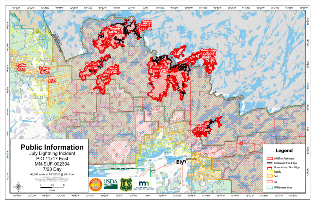
Executive Summary Today, the July Lightning Incident Command Post (ICP) will move from Memorial High School in Ely to Fortune Bay Resort Casino in Tower, so the district can prepare to welcome students back to school. The Southern Area CIMT 1 wants to thank school district staff for their kindness and hospitality. Best of luck in the upcoming school year! Combined acreage overall of the July Lightning Incident is 63,696 acres in the United States and an additional 8,443 acres in Canada. Estimated acreage of the Little Knife Fire is 4,958 acres. There are a total of 1,029 personnel on the July Lightning Incident. Containment estimates continue to increase based on current fire behavior, fuels, weather and natural barriers like lakes and waterways. Containment is a dynamic figure and can rise and fall based on fire activity. The public is being asked to support firefighters and public safety by adhering to all evacuations, closures, and fire restrictions; by refraining from flying drones, which endanger firefighting aircraft; and by keeping boats off the water in areas where water-gathering aircraft are operating. Fires reported on this update may change as some fires have merged or been moved into patrol status.
Evacuations and Closures An interactive map is available for residents and property owners to determine evacuation levels for their property. Residents and property owners can search this map by address to determine exact locations and evacuation levels. Click on the county name below for county-specific information.
Lake County: All evacuations remain in place. This morning, the Lake County Sheriff’s Office provided temporary escorted re-entry for a limited number of residents and property owners affected by the Camp Fire.
St. Louis County: “Ready” and “Set” zones west of the Echo Trail and the Crane Lake area have been completely lifted. Please visit the St. Louis County Emergency Management website for more information. St Louis County is not offering escorted re-entry of any of the “Go” evacuation areas at this time due to fire behavior and proximity to the fire area.
Cook County: The “READY” evacuations for Schroeder – Dist. 1, Tofte – Dist.1, and Lutsen – Dist. 1 have been lifted as of Wednesday, July 22 due to a reduction of fire behavior potential on the Little Knife Fire. The Gunflint Trail is still in “SET” and “READY” status between the end of the Gunflint Trail and mid-trail.
Superior National Forest: The Forest announced this morning select BWCAW entry points will open to the public for ‘Day Use’ on July 27, on the Gunflint and Tofte Districts (Eastern side of the forest), and BWCAW ‘Overnight’ permits will be cancelled July 25 – July 29, 2026. Forest Officials anticipate the ability to open select portions this next week to overnight use – barring no significant wildfire activity over the upcoming weekend. In an effort to re-open select areas of the BWCAW (as fire activity, weather and resources allows) the Forest Service continues to evaluate the affected BWCAW quota permit entry point areas for use on a daily basis. A Boundary Waters Canoe Area Wilderness (BWCAW) Closure Order is in place to protect public and firefighter health and safety.
Temporary Flight Restrictions are in place over certain portions of the fire area. Visit the Federal Aviation Administration (FAA) website for more information.
Fire Restrictions
Superior National Forest Forest-wide Fire Restrictions are in effect. Minnesota DNR fire restrictions are in effect.
Weather and Fire Behavior Stronger southwesterly winds will continue to bring warmer temperatures over the fire area into the weekend. Highs are forecast to reach the mid 80s while relative humidities will fall into the mid 30s to lower 40s. The combination of winds and hot, dry air will create elevated fire weather conditions, particularly on Friday. A 30% chance of rain showers exists today, but better chances for rain arrive late Friday. The small chance of afternoon showers is not predicted to impact fire behavior today. While today may not see significant fire spread, expect momentum to continue building as surface fire and isolated torching begin to increase in areas that have been relatively quiet.
Operations Non-Boundary Waters Canoe Area Wilderness Wildfires
Camp: Approximately 4,402 acres. 23% contained. Location – 5 miles north of Winton. Yesterday, helicopters dropped buckets of water on hot spots and crews finished constructing direct and indirect line along the southern and western fire perimeters. Today, crews will mop up along the southern fire perimeter and continue with structure protection along Fernberg Road towards Snowbank.
Sioux: Approximately 12,392 acres. 17% contained. Location – North of the Echo Trail and east of Jeanette Campground. Portions of the fire are burning in BWCAW. Yesterday, helicopters dropped buckets of water on hot spots and crews cleared trees and vegetation along Forest Road 199. Today, crews will continue clearing vegetation along Echo Trail and mop up hot spots south of Echo Trail.
Boundary Waters Canoe Area Wilderness Wildfires
Little Knife: Originated in Ontario and crossed into the United States. Fire activity was minimal on the Little Knife Fire yesterday and the fire remains at 4,958 acres. About 55 personnel are assigned, with engines assessing structures along the Gunflint Trail and incoming specialized crews preparing for strategic suppression in the BWCAW. Managed by the National Incident Management Organization (NIMO).
Bear Trap (Bear Trap and Dark Fires combined): Approximately 37,780 total acres (29,682 acres in the United States). 34% contained. Location – South of Lac La Croix, 20 miles north of Ely. Yesterday, helicopters dropped buckets of water on hot spots on the southern and western perimeters of the fire and continued structure protection around Big Lake. Today, crews will continue structure protection and clearing and widening Echo Trail to the east to connect the Echo Trail to the Camp Fire and to the west towards the Sioux Fire.
Thumb: 17,164 total acres (16,820 acres in the United States). 58% contained. Remote and located 6 miles south of Gakijiwanong Anishnaabe Nation Canada. Yesterday, scooper planes were used on the northern and western perimeters of the fire, while a hotshot crew was inserted into the northern portion of the fire area. Today, the hotshot crew on the northwestern edge of the fire near Takucmich Lake, south of Lac La Croix, will construct fireline and install sprinklers.
Wildfires West of Echo Lake and East of U.S. Hwy 53 The Chub Fire is the most active fire in this area. There is a combined containment of 87% on these eleven fires. Crews are identified to assist with initial attack for any new fires that are detected.
Chub: 344 acres. 86% contained. Location – North of Chub Lake, southwest of Crane Lake. Crews have secured dozer line and handlines and will continue with mop up to extinguish pockets of heat throughout the fire interior.
493, Echo 2, Beaver Tail, Ridge, Creek, Marion Creek Trail, Nine, Camp 5/Duck, Bug Creek, Coffin Fires: 64.4 acres combined for all ten fires. All are 100% contained. Crews continue to patrol these fires, searching for smoke and hot spots and extinguishing any lingering heat.
History On the evening of July 6, a dry thunderstorm moved across northeastern Minnesota and southern Canada resulting in more than 1,000 lightning strikes, causing dozens of fire starts. As unprecedented dry and warm conditions followed in the days after, fires were detected across Cook, Lake and St. Louis counties. Where fires were accessible by ground, firefighters were able to work to keep some of the fire perimeters small in size, however due to the number of fires, locations and number of firefighters and equipment, some of the fires continued to smolder and grow in the following days. Local fire managers ordered many additional resources including engines, hand crews, aviation resources and two incident management teams to support the firefighting efforts. While some of the fires were contained, several have continued to grow due to record breaking high temperatures and low humidity. Additional firefighters, equipment and support staff continue to be ordered including a Complex Incident Management Team.
July 22, 2026
Property Access for Residents Affected by the Camp (Branch III) Fire Closure
The Lake County Sheriff’s Office, in collaboration with the Southern Area Complex Incident Management Team, will provide an opportunity for residents and property owners affected by the Camp (Branch III) Fire closure to access their properties on Thursday, July 23, 2026, from 8:00 a.m. to 2:00 p.m.
Property owners and authorized individuals must present identification to verify residency, property ownership, or other authorized access. Acceptable documentation includes:
Driver’s license or state-issued identification card
Utility bill
Property tax statement
Voter registration card or other documentation demonstrating residency or property ownership
Additional documentation may be accepted at the discretion of the Lake County Sheriff’s Office.
Escort Procedure
Check-in will begin at 7:30 a.m. at the Fall Lake Township Hall, located at 393 Kawishiwi Trail, Ely, MN 55731.
After check-in, participants will receive an access pass and be escorted by Lake County Sheriff’s Office deputies to their properties.
Individuals must remain on their respective properties while within the closure area.
Participants will be escorted out of the closure area by Lake County Sheriff’s Office deputies.
Upon leaving the closure area, participants must check out with Lake County Sheriff’s Office staff at the Fall Lake Township Hall.
The Lake County Sheriff’s Office would like to thank all residents, property owners, and business owners for their patience and cooperation during this challenging time. Your safety and well-being remain our top priority as we continue to respond to this incident. We appreciate your understanding and support as response efforts continue.
July Lightning Incident/Little Knife Fire Daily Update July 21, 2026, 10:00 am
Executive Summary Combined acreage overall of the July Lightning Incident is 63,587 acres in the United States and an additional 8,412 acres in Canada. Estimated acreage of the Little Knife Fire is 4,598 acres. There are a total of 780 personnel on the July Lightning Incident. The public is being asked to support firefighters and public safety by adhering to all evacuations, closures, and fire restrictions; by refraining from flying drones, which endanger firefighting aircraft; and by keeping boats off the water in areas where water-gathering aircraft are operating. Fires reported on this update may change as some fires have merged or been moved into patrol status. A Lutsen Township community informational meeting for the Little Knife Fire is planned for tonight (Tuesday, July 21) during the Lutsen Town Board Meeting at 7 PM. The meeting is open to the public and will be held at the Lutsen Town Hall (116 Caribou Trail). WTIP Radio will be live broadcasting and plans to livestream the meeting. The Superior National Forest Facebook page also intends to live stream the meeting.
Evacuations and Closures Lake County: “GO” status for Hwy 16/Fernberg Corridor from the Garden Lake Bridge to the end of the Fernberg at Lake One due to the Camp Fire. Evacuate immediately.
St. Louis County: “GO” status was updated on July 18th for additional areas near the Echo Trail and “Ready” for the City of Winton north Burnside Lake. “GO” status for portions of the Echo Trail from Big Lake up to the 200 Road near the Sioux Fire. Other areas are under “SET” evacuation notice for Marian Creek, Ridge, Beaver Tail, Coffin & Echo 2 Fires
Cook County: “SET” status at the end of the Gunflint Trail due to the Little Knife Fire. The Midtrail area of the Gunflint Trail west of Hungry Jack Lake Rd. and the northern parts of the townships of Schroeder, Tofte, and Lutsen have moved into “READY” status.
Superior National Forest: has extended Boundary Waters Canoe Area Wilderness (BWCAW) Closure Order to protect public and firefighter health and safety through July 24. The BWCAW permit issuance and forest closure is being evaluated daily. Notifications are being made to permittees seven days prior to permit entry date.
Temporary Flight Restrictions are in place over certain portions of the fire area. Visit the Federal Aviation Administration (FAA) website for more information.
Weather and Fire Behavior Cooler weather is expected today as mostly cloudy skies will limit the amount of sunlight we receive. Highs in the mid to upper 60s are forecast, keeping relative humidity values a bit higher than the previous two days at 46 to 54 percent. North-northwesterly winds will be strong this morning, with gusts of 19 to 26 miles per hour, but will gradually slow down late this afternoon. A 20% chance of light rain showers exists until about 1PM before skies begin to partially clear in the late afternoon. Even with cooler temperatures, surface drying will increase with strong winds today and contribute to increased activity. With lower chances of precipitation today, expect to see fire danger indices and associated fire activity to begin increasing and building momentum. Areas where smoldering and creeping occurred over the last few days will begin to see a transition to surface fire. Pockets of pine and fir will begin to see isolated torching. The potential for initial attack response to holdover lightning fires exists. Stronger winds may hide smoke in the trees longer today, increasing the chance for fires to be well established before detection.
Operations Non-Boundary Waters Canoe Area Wilderness Wildfires
Camp: Approximately 4,402 acres. Location–5 miles north of Winton. Handcrews continued to build direct handline along the entire southern perimeter of the fire, connecting to Newton Lake on the east and other natural features on the west. Crews will continue to build and improve direct and indirect lines and structure protection along Fernberg Road, identifying structures and potential for contingency lines to the south and east out to Snowbank.
Sioux: Approximately 12,354 acres. Location–North of the Echo Trail and east of Jeanette Campground. Portions of the fire are burning in BWCAW. Handcrews continue to work on establishing direct handline on the southern perimeter of the fire that crossed Echo Trail including digging handline and installing hoselays and a sprinkler system. This work with handcrews will continue today. Firefighters continue working further south from the immediate fire perimeter to develop a plan for additional indirect containment lines.
Boundary Waters Canoe Area Wilderness Wildfires
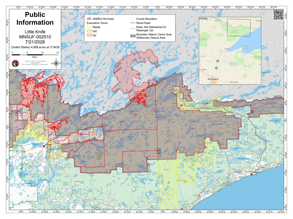
Little Knife: Originated in Ontario and crossed into the United States. The approximate fire acreage in the United States has been reduced to 4,598 acres due to more accurate mapping. Fire activity is currently minimal. Multiple reconnaissance flights have been conducted and a Chinook aircraft was used to strategically drop water on hot spots. Managed by the National Incident Management Organization (NIMO).
Bear Trap (Bear Trap and Dark Fires combined): Approximately 37,747 total acres (29,682 acres in the United States). Location–South of Lac La Croix, 20 miles north of Ely. Structure protection with hose lays and sprinklers continued around the northern edge of Big Lake in Whispering Pines and Big Lake Lodge as well as private properties on the south side of the lake. Today, structure protection will continue around Big Lake as well as crews and equipment will begin clearing and widening the Echo Trail to the east to connect the Echo Trail to the Camp Fire and to the west towards the Sioux Fire.
Thumb: 17,088 total acres (16,747 acres in the United States). Remote and located 6 miles south of Gakijiwanong Anishnaabe Nation Canada. The majority of fire activity was along the southwestern perimeter of the fire area, where the fire is backing down into natural barriers, close to the northern perimeter of the Sioux Fire. Aviation resources will monitor the fire during today’s operations
Wildfires West of Echo Lake and East of U.S. Hwy 53 The Chub Fire is the most active fire in this area. All the fires have firefighters and engines working on a variety of suppression tactics including building line, mopping up and patrolling and monitoring. There is a combined containment of 57% on these eleven fires.
Chub: 347.8 acres. 50% contained. Location – North of Chub Lake, southwest of Crane Lake. Crews will secure dozer line and handlines, followed by mop up and gridding to extinguish pockets of heat throughout the fire’s interior.
493: 0.7 acre. Location – South of Long Lake. Crews will secure dozer line and handlines, followed by mop up and gridding to extinguish pockets of heat throughout the fire’s interior.
Echo 2: 16.5 acres. 100% contained. Location – off the Echo Rapids Road, north of Echo Lake. Crews will continue to patrol the fire, searching for smoke or hot spots and extinguishing any lingering heat.
Beaver Tail: 11.6 acres. 100% contained. Location – West of the Vermilion River. Crews continue mop up, using hand tools and water to put out remaining pockets of heat, as they grid throughout the fire interior.
Ridge: 8 acres. 100% contained. Location – East of the Vermilion River. Crews will continue to patrol the fire, searching for smoke or hot spots and extinguishing any lingering heat.
Creek: 4.1 acres. 100% contained. Location – Crews will continue to patrol the fire and mop up, searching for smoke and hot spots and extinguishing any lingering heat.
Marion Creek Trail: 12.2 acres. 100% contained. Location – West of the Vermilion River. Crews will continue to patrol the fire, searching for smoke and lingering heat.
Nine: 5.4 acres. 100% contained. Location – South of Echo Lake. Crews will continue to patrol the fire, searching for smoke and any lingering heat.
Camp 5/Duck: 4.0 acres, 100% contained (Camp Fire); 0.5 acres, 100% contained (Duck Fire). Location – North of Elephant Lake. Crews will continue to patrol the fire, searching for smoke and hot spots, then extinguishing any lingering heat
Bug Creek: 0.1 acre. 100% contained. Crews continue to patrol the fire, searching for smoke and lingering heat.
Coffin Fire: 0.1 acre. 100% contained. Crews will continue to patrol the fire, searching for smoke and any lingering heat.
History On the evening of July 6, a dry thunderstorm moved across northeastern Minnesota and southern Canada resulting in more than 1,000 lightning strikes, causing dozens of fire starts. As unprecedented dry and warm conditions followed in the days after, fires were detected across Cook, Lake and St. Louis counties. Where fires were accessible by ground, firefighters were able to work to keep some of the fire perimeters small in size, however due to the number of fires, locations and number of firefighters and equipment, some of the fires continued to smolder and grow in the following days. Local fire managers ordered many additional resources including engines, hand crews, aviation resources and two incident management teams to support the firefighting efforts. While some of the fires were contained, several have continued to grow due to record breaking high temperatures and low humidity. Additional firefighters, equipment and support staff continue to be ordered including a Complex Incident Management Team.
Camp Fire (also known as Branch III) update
Monday, July 20, 2026 – 2:00 pm
Emergency Manager- Warren LaPlante
Wildfire Evacuation Guidance: Ready, Set, Go!
As fire conditions continue to change, residents should be prepared to act quickly. Know your evacuation status and take the appropriate steps below.
READY – Be Prepared
Residents in a Ready zone should begin preparing now.
Create an evacuation plan and identify meeting locations and evacuation routes.
Assemble an emergency kit with medications, important documents, pet supplies, clothing, and other essential items.
Prepare your home by removing combustible materials around structures when it is safe to do so.Stay informed by monitoring official updates and be prepared if your evacuation status changes.
SET – Be Ready to Leave
Residents in a Set zone should be prepared to evacuate at a moment’s notice.
Pack your vehicle with essential belongings.
Don’t forget the 6 P’s:
People and Pets
Papers (important documents)
Prescriptions and medications
Pictures and irreplaceable keepsakes
Personal computers and important electronic data
Plastics (credit cards) and cash
Wear sturdy clothing and closed-toe shoes.
Keep your vehicle fueled and backed into the driveway for a quick departure.
If you feel unsafe, leave immediately– do not wait for an official evacuation order.
GO – Evacuate Immediately
Residents in a Go zone should leave immediately.
Take your family, pets, medications, important documents, and emergency supplies.
Follow designated evacuation routes and directions from emergency personnel.
Close all windows, leave doors unlocked, and leave exterior lights on if power is available to help firefighters identify your home.
Do not return to the area until evacuation orders have been lifted by local authorities.
Continue to monitor official updates from the Lake County Sheriff’s Office and emergency management officials for the latest information on evacuation zones, road closures, and fire conditions.
For continued updates, please visit the Lake County website.
FOREST SERVICE U.S. Department of Agriculture Minnesota Incident Command System Superior National Forest & July Lightning Wildfires Facts Sheet, July 17, 2026, 12:00 pm
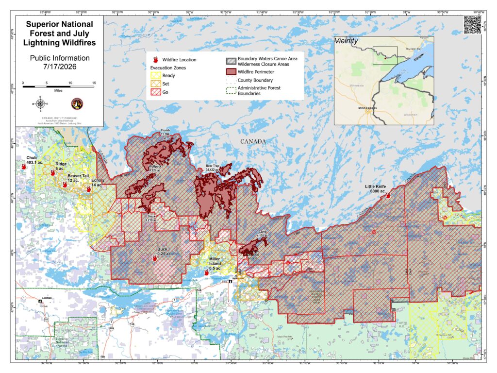
Superior National Forest | Evacuation Status Lake County: Initiated the “GO” for Hwy 16/Fernberg Corridor from the Garden Lake Bridge to the end of the Fernberg at Lake One due to the Camp Fire. Evacuate immediately. A temporary evacuation site has been established at the Babbitt Municipal Building at 71 S Drive, Babbitt (hours may vary).
St. Louis County: Initiated “GO” for portions of the Echo Trail from Big Lake up to the 200 Road near the Sioux Fire. Other areas are under “SET” evacuation notice for Marian Creek, Ridge, Beaver Tail, Coffin and Echo 2 Fires
Cook County: Remains at “SET” status at the end of the Gunflint Trail due to the Little Knife Fire. The Midtrail area of the Gunflint Trail west of Hungry Jack Lake Rd. and the northern parts of the townships of Schroeder, Tofte, and Lutsen have moved into “READY” status.
Closures & Fire Restrictions Superior National Forest has issued an Expanded BWCAW Closure Order to protect public and firefighter health and safety. The BWCAW permit issuance is being evaluated daily with notifications to permittees 4-days prior to permit entry date. Forest-wide fire restrictions are also in effect.
Key Messages The forecast for erratic weather, shifting winds and the potential for isolated damaging wind gusts and thunderstorms will be a challenge for firefighting efforts. Approximately 13,000 lightning strikes were detected with the storms that moved through the area this morning. New fires may be detected as the sun comes out. Before the rain, crews in some areas saw as many as five trees fall across the Echo Trail in the span of 1/2 hour. Heavy smoke has impacted air operations, making it difficult to track the perimeter of some of these fires. Over 500 firefighters and support personnel are involved in these fires, with additional resources arriving daily. In addition, over 16 state and local fire departments are involved in the firefighting efforts.
Wildfires Currently, the forest has 16 active wildfires, with 3 active fires inside the BWCAW. Some fires have merged. When that happens, the fire is given the name of one of the fires. This also changes the number of fires that are reported here.
Non-Boundary Waters Canoe Area Wilderness wildfires
Camp Fire started 7/7/2026. Size–2,886 acres. Location–5 miles north of Winton. Cause: Lightning. Status: Extreme fire behavior and some growth yesterday and overnight. Evacuations in effect from this fire. Firefighters are conducting structure protection and suppression with day and night shifts.
Sioux Fire started 7/9/2026. Size–approximately 7,368 acres. Location–North of the Echo Trail and east of Jeanette Campground. Portions of the fire are burning in BWCAW. Extreme fire behavior and some growth yesterday and overnight. Firefighters are utilizing structure protection, including around the Meander Lake communication site and generator. The fire crossed Echo Trail near the Little Indian Sioux River. Cause: Lightning.
Crescent Fire started 7/14/26. Size- .5 acre. Location- Island in Crescent Lake, Tofte. Human-caused. Contained and will continue to monitor.
Birch Island (.25ac), Buck Fire (.1ac), are in patrol status.
Boundary Waters Canoe Area Wilderness wildfires
Little Knife started 7/15/2026. Size- estimated at 6,000 acres (US side). Smoke has hampered visibility for mapping purposes. Location- heat detection mapping showed growth as far south as Ogishkemuncie Lake. The fire has burned a total of 30,000 acres.
Bear Trap Fire started 7/7/2026. Total size of combined Bear Trap and Dark fires: Approximately 13,500 acres. Location–South of Lac La Croix, 20 miles N of Ely. Status–Extreme fire behavior with crowning, torching and spotting. Fire crossed the international border and entered Canada and has pushed to within 1/2 mile of the Echo Trail.
Thumb Fire started 7/7/2026. Size–14,129 acres. Location–remote & located 6 miles S of Gakijiwanong Anishnaabe Nation Canada. Cause: Lightning. Status Remote with difficult access. Active fire behavior. This fire has crossed the Canadian Border. Aircraft continue to suppress the fire on the US side as conditions allow.
Minnesota Incident Command System managed wildfires
Echo 2 Fire started 7/8/2026. Size – 16.4 acres. Location – off the Echo Rapids Road, north of Echo Lake. Moderate fire activity yesterday. Firefighters will continue to improve containment lines and search for and extinguish any found heat.
Chub Fire started 7/9/2026. Size – 337 acres. Location – North of Chub Lake, southwest of Crane Lake. The fire was less active yesterday and crews utilized a dozer to establish control and contingency lines. Today firefighters will continue to improve dozer lines and handlines around the fire’s perimeter.
Beaver Tail started 7/9/2026. Size – 12 acres. Location – West of the Vermilion River. Low to moderate fire activity yesterday. A control line has been established along the entire perimeter of the fire. Crews will search for and extinguish any found heat.
Ridge Fire started 7/9/2026. Size – 8 acres. Location – East of the Vermilion River. Minimal fire behavior yesterday. Crews will continue to reinforce and improve containment and control lines around the fire and cool any hot spots found.
Creek Fire started 7/9/2026. Size – 4 acres. Location – Northwest of Chub Lake. Minimal fire activity yesterday. Firefighters continue to strengthen and improve control lines with crews and equipment. 2
Marion Creek started 7/9/2026. Size – 16 acres. Location – West of the Vermilion River. No significant fire activity yesterday. Crews established dozer line around the fire. Today, firefighters will work to improve the control lines and install hose lines.
Nine Fire started 7/9/2026. Size – 5.4 acres. Location – South of Echo Lake. Minimal fire activity yesterday. Firefighters continue to mop up and to search for an extinguish any found heat.
Camp 5/Duck Fire started 7/9/2026. Size – 4 acres. Location – North of Elephant Lake. Minimal to no fire activity was detected. A dozer will work to improve control lines around the Camp 5 Fire today.
Bug Creek & Coffin Fires started 7/9/2026. Size – 0.2 acre. Aircraft and firefighters continue to verify the fires remain secure by checking for smoke and remaining heat.
Canadian managed wildfires
Canada is experiencing similar fire activity. Multiple fires have crossed the International Border. The forest is coordinating with Canadian fire officials. Ontario Wildfire Information.
Background On the evening of July 6, 2026, a storm system moved through the area with lightning and little precipitation. The following day, several small wildfires were reported. Local and off‑forest firefighting resources are conducting suppression on these fires. With warm and dry summer conditions, additional wildfires are being detected daily.
National Weather Service Forecast Stormy conditions are expected today with a high likelihood of showers and thunderstorms. There is the potential for isolated damaging wind gusts associated with the stronger storms along with localized heavy rain. Rain amounts of 0.25 to 0.50 inches are expected with isolated higher amounts where thunderstorms persist. Winds during the morning are expected to be from the southeast then switch to the northwest between 1300-1500 with the passage of a cold front with gusts of 15 to 20 mph.
Safety Messages Flying drones or other aircraft over the fire is prohibited. If non-authorized aircraft are detected near the fire, any air operations supporting the fire will stop. Drones are illegal in federally designated wilderness areas and compromise the safety of firefighters and hinder fire operations. Recreational boaters and property owners on waterways where aircraft are water-gathering are urged to remain on the shoreline. Watercraft idling in wide bays will force emergency aircraft to abort their mission.
Camp Fire update
Thursday, July 16, 2026 – 4:00 p.m.
Emergency Manager- Warren LaPlante
The temporary evacuation point at the Babbitt Municipal Building, 71 South Drive, Babbitt, MN, will close at 9:00 p.m. on Thursday, July 16. The evacuation point will remain closed unless additional needs arise.
Air quality is hazardous for everyone throughout Lake County on 7/16/2026. It’s expected to remain unhealthy through at least July 17, 2026. Monitor changes to air quality via local news or by visiting www.airnow.gov. Protect your health by avoiding outdoor activities, shutting windows and doors and using air purifiers or air conditioners set to recirculate. If you must be outside, consider using an N95 mask. For people at higher risk due to medical conditions or other factors, N95 masks are available at the Lake County Service Center, 616 3rd Ave., Two Harbors during regular business hours, 8:00 a.m. to 4:00 p.m. Monday through Friday.
Camp Fire update
Wednesday, July 15, 2026 – 4:30 p.m.
Emergency Manager- Warren LaPlante
FOR IMMEDIATE RELEASE
Additional “GO!” evacuation notifications will now be displayed across the Boundary Waters Canoe Area Wilderness (BWCAW) in Cook, Lake, and St. Louis counties to align with the Boundary Waters Canoe Area Wilderness Closure, which was updated on July 13, 2026. This change ensures consistency between the National Forest System lands and county evacuation messaging. It does not affect any additional residences or private property.
Fire managers, the USDA Forest Service, the Minnesota Department of Natural Resources, and officials from Cook, Lake, and St. Louis counties continue to meet regularly to assess fire conditions and coordinate response efforts. These meetings help ensure that advance notice can be provided to the public if changes to Ready, Set, Go evacuation statuses become necessary.
As part of the response to the Camp Fire, Lake County established a temporary evacuation point at the Babbitt Municipal Building, 71 South Drive, Babbitt, Minnesota, on July 14, 2026. Public Health staff from Lake County and St. Louis County have been jointly staffing the facility each day from 8:00 a.m. to 9:00 p.m.
The temporary evacuation point will remain open on Thursday, July 16. Any residents impacted by the fire, heat or poor air quality are welcome to utilize the facility during operating hours.
Camp Fire update
Tuesday, July 14, 2026 – 5:00 p.m.
Emergency Manager- Warren LaPlante
Public Information Update – Evacuation Resources
The temporary evacuation point at the Babbitt Municipal Center will remain open until 9:00 p.m. today and will reopen Wednesday, July 15, at 8:00 a.m.
Sheltering: There are no public shelters available at this time.
Pet Assistance: The Ely Veterinary Clinic has travel kennels available to borrow for anyone needing a safe way to transport pets during the fire evacuations. Residents may stop by the clinic to borrow a kennel.
For those who need emergency pet boarding, Pup North in Eveleth has generously offered assistance. Please call 218-744-1477 for boarding arrangements.
Donations: At this time, no donations have been identified as needed for evacuees. If needs arise, additional information will be shared through official county communication channels.
Residents are encouraged to continue monitoring Lake County’s website and official county communication channels for the latest updates.
Camp Fire update
Tuesday, July 14, 2026 – 11:00 a.m.
Emergency Manager- Warren LaPlante
Amended Evacuation Notice
The Lake County Sheriff’s Office, in coordination with the U.S. Forest Service, is issuing an expansion to the evacuation zone, which will now include the area in between Fall Lake and Cedar Lake. The zone is titled “North Fall Lake – 2A” on the evacuation zone map located on the Lake County website.
The evacuation status for this area has been elevated to GO. Residents and visitors should leave immediately.
The evacuation still includes all adjoining roads, driveways, and trails from Lake One and Snowbank Lake to the Garden Lake Bridge.
Before leaving, bring:
Prescription medications
Important documents
Credit cards and cash
Pets and necessary pet supplies
The Lake County Sheriff’s Office will conduct door-to-door notifications throughout the GO evacuation zone. Residents are urged to remain alert to changing conditions and follow all evacuation orders and instructions from local officials.
Temporary Evacuation Point
A Temporary Evacuation Point opened at 8:30 a.m. at:
Babbitt Municipal Building 71 South Dr. Babbitt, MN 55706
The site will be staffed throughout the day. Anyone who anticipates needing overnight shelter is encouraged to check in as early as possible.
Evacuation Zone Map
An interactive evacuation map is available on the Lake County website.
To view the map:
Visit the Lake County website.
Select “Lake County Mapping and Online Parcel Mapping.”
Open the map and select the “Fire Evacuation” tab in the lower-right corner.
The U.S. Forest Service continues to monitor the Camp Fire and is working closely with the Lake County Sheriff’s Office, Emergency Management, and other responding agencies to assess fire behavior and coordinate response efforts.
Residents and visitors should continue to monitor official updates for the latest information on fire conditions, evacuation zones, road closures, and public safety guidance.
For continued updates, please visit the Lake County website.
Camp Fire Update Monday, July 14, 2026 – 6:00 a.m.
Emergency Manager: Warren LaPlante
Immediate Evacuation Notice
The Lake County Sheriff’s Office, in coordination with the U.S. Forest Service, is issuing an IMMEDIATE EVACUATION for the Fernberg Road Corridor beginning at 7:00 a.m. on Tuesday, July 14, 2026.
The evacuation includes all adjoining roads, driveways, and trails from Lake One and Snowbank Lake to the Garden Lake Bridge.
The evacuation status for this area has been elevated to GO. Residents and visitors should leave immediately.
Before leaving, bring:
Prescription medications
Important documents
Credit cards and cash
Pets and necessary pet supplies
The Lake County Sheriff’s Office will conduct door-to-door notifications throughout the GO evacuation zone. Residents are urged to remain alert to changing conditions and follow all evacuation orders and instructions from local officials.
Temporary Evacuation Point
A Temporary Evacuation Point will open at 8:30 a.m. at:
Babbitt Municipal Building 71 South Dr. Babbitt, MN 55706
The site will be staffed throughout the day. Anyone who anticipates needing overnight shelter is encouraged to check in as early as possible.
Additional Evacuation Zone Changes
Evacuation levels have changed in other areas as well. Residents and visitors should check the Lake County website regularly for the most current evacuation zones and public safety information.
These changes are based on forecasted weather conditions that could result in rapid wildfire growth, heavy smoke, reduced visibility, and hazardous air quality.
Evacuation Zone Map
An interactive evacuation map is available on the Lake County website.
To view the map:
Visit the Lake County website.
Select “Lake County Mapping and Online Parcel Mapping.”
Open the map and select the “Fire Evacuation” tab in the lower-right corner.
The U.S. Forest Service continues to monitor the Camp Fire and is working closely with the Lake County Sheriff’s Office, Emergency Management, and other responding agencies to assess fire behavior and coordinate response efforts.
Residents and visitors should continue to monitor official updates for the latest information on fire conditions, evacuation zones, road closures, and public safety guidance.
For continued updates, please visit the Lake County website.
Camp Fire update
Monday, July 13, 2026 – 5:00 PM
Emergency Manager- Warren LaPlante
Camp Fire in Superior National Forest Becomes Active; Evacuation Zones Implemented
The Camp Fire, located in the Superior National Forest, has become active and is currently burning in a northeast direction. The fire is being closely monitored by the U.S. Forest Service and other responding agencies as crews work to assess conditions and support public safety efforts.
The Camp Fire was first reported on July 7, 2026, and initially burned approximately 1.6 acres. The fire began approximately 8 miles north/northeast of the Cloquet Line, outside the Boundary Waters Canoe Area Wilderness (BWCAW). The cause of the fire has been determined to be lightning.
The fire has reignited, and due to increased fire activity, the Lake County Sheriff’s Office, in coordination with the U.S. Forest Service and other emergency responders, has implemented the Ready, Set, Go! notification plan. Evacuation zones have been established and updated based on current fire conditions and the potential risk to nearby areas.
The Lake County Sheriff’s Office has been actively working in the affected area and conducted door-to-door notifications within the “Go” evacuation zone. Residents are encouraged to remain aware of changing conditions and follow all evacuation notifications and instructions from local officials.
An evacuation zone map is available on the Lake County website. To access the map:
Visit the Lake County website.
Select “Lake County Mapping and Online Parcel Mapping” from the main page.
Open the map and select the “Fire Evacuation” tab located in the bottom-right corner.
The U.S. Forest Service is actively monitoring the Camp Fire and coordinating with Lake County officials and other responders to evaluate fire behavior and determine appropriate response actions.
Residents and visitors are encouraged to continue monitoring official updates from Lake County and emergency management officials for the latest information regarding fire conditions, evacuation zones, and public safety guidance.
For continued updates, please visit the Lake County website.
Project Location: 15th Street, City of Two Harbors Work Type: Bituminous Mill & Overlay Anticipated Construction Start Date: September 8, 2026 Final Completion Date: November 6, 2026
Public Comment Period for an Environmental Assessment Worksheet (EAW)
PROJECT TITLE Silver Rapids Lodge
PROJECT DESCRIPTION Leisure Hotels and Resorts is proposing construction of an update to and expansion of the existing Silver Rapids Lodge resort site located in Fall Lake Township, Lake County, Minnesota. The project will include demolition of a functionally obsolete lodge, the construction of a new lodge, 44 new cabins, as well as other amenities.
PROJECT LOCATION 459 KAWISHIWI TRL, ELY MN
Part of lot 5 as described in doc no A000160700 in Section 29and lot 3 less W 400ft in Section 32 in Township 63 Range 11; 48.47 total acres in Fall Lake Township Parcels 28-6311-29850 & 28-6311-32070
EAW MAY BE VIEWED AT
Lake County Environmental Services Department Lake County Courthouse 601 Third Avenue Two Harbors, MN 55616 218-834-8327
ONLY WRITTEN COMMENTS MAY BE SUBMITTED. PLEASE MAIL OR EMAIL: Bryr Ludington, Environmental Services Director Lake County Environmental Services Department 601 Third Avenue, Two Harbors, MN 55616 bryr.ludington@lakecountymn.gov
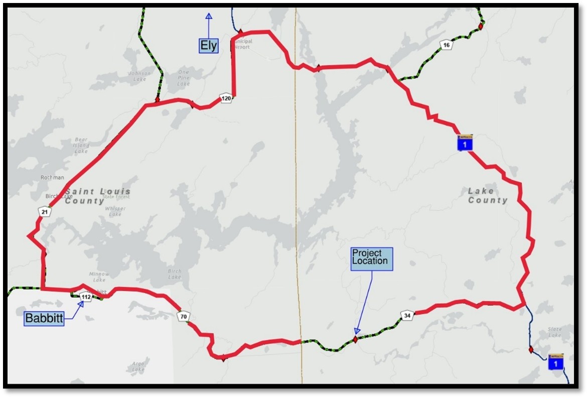
NOTICE Lake County Highway Department will be closing New Tomahawk Road (County Road 34) to through traffic between MN Hwy 1 and Babbit.
When Beginning: Tuesday July 7, 7:00AM Ending: September 19, (anticipated)
Why The bridge over Stony River will be rehabilitated, including a new bridge deck and railing and repairs to substructure units.
Residential Access The bridge will be out, no traffic can cross for the duration of the project. A detour will be posted on MN Hwy 1 and St. Louis County Roads 20 and 121. The road will be open to residents and local traffic on either side of the bridge.
NOTICE Lake County Highway Department will be closing 15th Street (County Road 27) to through traffic between August Omtvedt Blvd (County Road 27) and 20th Avenue (County Road 28) beginning July 6, 2026.
When Beginning: Monday July 6, 7:00AM Ending: Monday July 13, 7:00AM (anticipated)
Why This closure has been requested by CN rail to facilitate upgrading the railroad crossing on 15th Street near Marie Avenue. The tracks and rail crossing surface will be removed and will not be open to highway traffic.
Residential Access The road will be open to residents and local traffic on either side of the rail crossing closure.
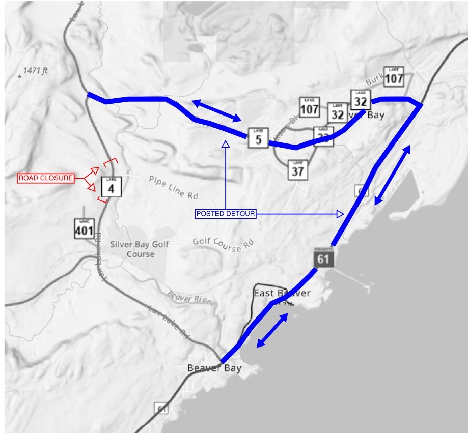
NOTICE Lax Lake Road (CSAH 4) between Airport Road (CSAH 3) and Forest Highway 11 (CSAH 5) will be closed to all traffic beginning July 6, 2026. Details as follows:
When Beginning: July 6 Ending: July 10
Purpose The closure is necessary for Cliffs Northshore Mining to complete a permitted utility replacement project across Lax Lake Road.
Traffic Impacts A detour route will be posted, utilizing MN 61 and Outer Drive/Penn Blvd (Forest Highway 11) through Silver Bay.
Lake County is looking for election judges for the 2026 State Primary and General Elections. If you are interested and available to serve, please complete the Lake County Election Judge Interest Form at: https://www.co.lake.mn.us/auditor/become-an-election-judge/.
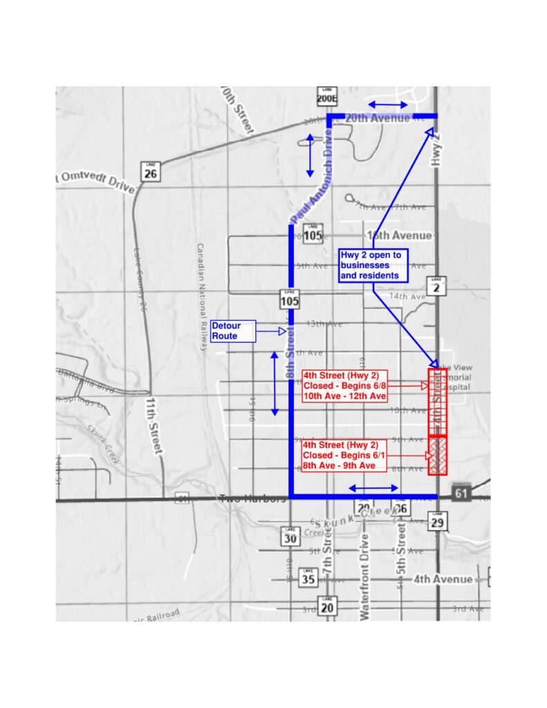
NOTICE 4th Street (Hwy 2) in Two Harbors will be closed to traffic between 7th Avenue (Hwy 61) and 12th Avenue, including the intersection 12th Avenue (see image attached).
When Beginning: June 1 Ending: July 17 (estimated)
Purpose The closure is necessary for the City of Two Harbors and their contractor to complete improvements on city owned water systems.
Work Schedule Details Work will begin June 1 at 8th and 9th Avenues. Work at 10th, 11th and 12th Avenues will begin June 8th.
Traffic Impacts A detour route will be posted utilizing 8th Street, Paul Antonich Drive, and 20th Avenue (Hwy 26). 4th Street will remain open to residents and businesses between 12th Avenue and 20th Avenue. Access for residents and businesses with driveways between 8th Avenue and 12th Avenue will be coordinated with project personnel. Access to the hospital will be maintained at all times but will need to be accessed via 10th, 11th or 12th Avenues.
Please contact Zeke Myers at 507-613-8905 or zeke.myers@bolton-menk.com with any project, traffic, or access related questions or concerns.
UPDATE: The Davis Drive intersection will not close until later this construction season; an updated closure schedule will be provided when determined. The contractor has developed an updated plan to minimize the risk of water service disruption due the condition of the existing water system and planned pipe replacement work. Utility work is ongoing immediately west of the Banks Blvd and eastern Davis Drive intersection and the intersection will remain open for Davis Drive traffic. Please be aware of construction vehicle traffic and workers entering and exiting the work zone at this intersection.
NOTICE The Banks Boulevard reconstruction project in Silver Bay will resume with street closures beginning Monday, May 18.
Davis Drive: Closed to all traffic at Banks Blvd intersection
Closure duration: 3 weeks
Access to city hall/police station from Outer Drive
Access for residents on Davis Drive/Drake Cir via Banks Blvd and west Davis Drive intersection
Access for residents east of Davis Drive via Adams Blvd.
Banks Blvd:
Closure duration: ~3 months
Closed to through traffic between Edison Blvd and Davis Drive (east).
Open to local traffic as provided by the contractor.
Access from west end of construction limits while Davis Drive (east) is closed
As part of the ongoing Stewart Trail Fire response and recovery effort, Lake County, in coordination with the Minnesota Department of Public Safety and the Minnesota Pollution Control Agency, has established temporary disposal sites for fire-related debris.
Where Can I Dispose of Burned Debris?
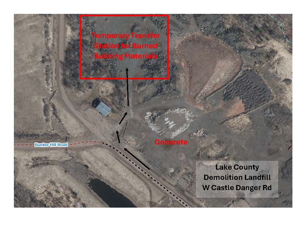
Emergency Temporary Transfer Station
Location: Lake County Demolition Landfill, West Castle Danger Road Hours: Tuesday and Thursday, 10:00 a.m.–5:00 p.m., or by appointment. For appointments, contact Environmental Services at 218-834-8304. Open through July 2, 2026
No disposal fees will be charged for eligible burned debris.
Accepted materials:
Burned non-vegetative debris that cannot be accepted at the Recycling Center or the established landfill disposal sites
Burned building materials
Demolition debris
Fire-related ash
This temporary site is available only for properties impacted by the Stewart Trail Fire. Staff will ask for the property address to verify eligibility.
Emergency Temporary Transfer Station Map
Lake County has received approval from the Minnesota Pollution Control Agency to establish this temporary disposal area for burned building and demolition materials from Stewart Trail Fire-affected properties.
Please use the Recycling Center and other designated landfill disposal areas whenever possible for materials accepted at those locations.
Important: The Temporary Transfer Station will close on July 2, 2026. After that date, burned building materials, demolition debris, and ash will no longer be accepted at the Lake County Demolition Landfill.
Lake County Recycling Center
Location: 515 Recycle Center Drive Hours: Monday–Friday, 9:00 a.m.–3:00 p.m.
Accepted materials:
Appliances
Electronics
Tires
Household Hazardous Waste (HHW)
Lake County Demolition Landfill (Established Sites)
Location: West Castle Danger Road Hours: Tuesday and Thursday, 10:00 a.m.–5:00 p.m.
Accepted materials:
Scrap metal
Concrete
Small amounts of burned or green brush
No root balls
No trunks larger than 12 inches in diameter
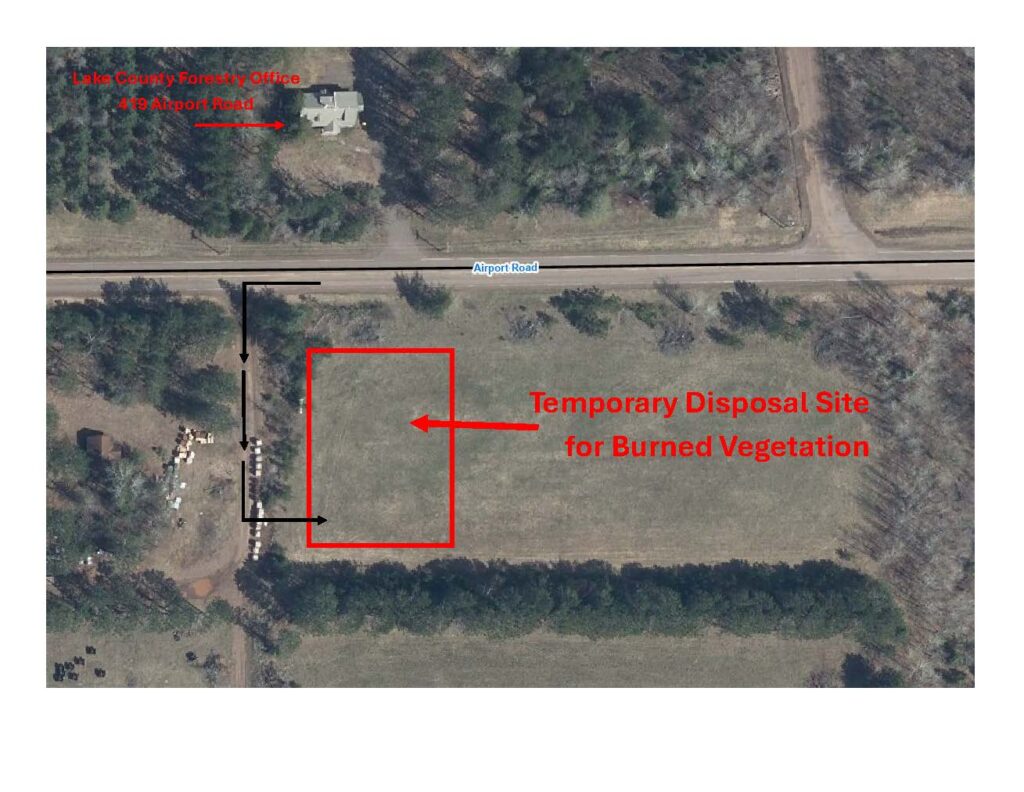
Temporary Burned Vegetation Disposal Site
Location: Field across from the County Forestry Office, 419 Airport Road Hours: Open 24 hours a day, 7 days a week
Accepted Materials
Burned vegetation debris only
Not Accepted
The following materials must be taken to the appropriate disposal locations listed above:
Burned building materials
Demolition debris
Household waste
Appliances
Metal
Concrete
Ash
Any other non-vegetative fire debris
Temporary Burned Vegetation Disposal Site Map
This site is dedicated exclusively to burned vegetation debris from properties impacted by the Stewart Trail Fire. Please follow all posted signs when entering and using the site.
The site will be monitored. If unauthorized materials are deposited, Lake County may restrict access or temporarily close the site.
Please check the County website for updates, as the site may close temporarily during significant rainfall or other conditions that affect safe access and operations.
Information for Commercial Contractors
Commercial contractors hauling burned vegetation debris on behalf of impacted property owners must contact Environmental Services at 218-834-8304 before delivering material.
Please provide:
The property location where the debris originated
The estimated volume of material
The anticipated hauling schedule
Thank you for your cooperation as Lake County works to support safe and efficient wildfire recovery efforts.
Stewart Trail Fire update Tuesday, May 26, 2026 Emergency Manager- Warren LaPlante
Lake County will host a Community Outreach Event for property owners whose property was damaged by the Stewart Trail Fire. This includes, but is not limited to, damage involving homes or other structures, septic systems, and burned or damaged trees.
Date: May 28, 2026 Time: Doors open at 5:00 p.m. and close at 7:00 p.m. Location: Sonju Arena Address: 301 8th Ave, Two Harbors, MN
Agencies and Organizations Available
Lake County Departments/Offices
Public Health
Planning and Environmental Services
Recorder’s Office
Auditor’s Office
Veterans Service Office
Emergency Management
State and Community Partners
Minnesota DNR Forestry and Restoration
Minnesota Homeland Security and Emergency Management
Minnesota Department of Commerce (Insurance Regulation)
United Way
American Red Cross
Two Harbors Food Shelf
Justice North (Nonprofit Legal Support)
Property owners who are unable to attend the event may direct questions to:
Lake County is partnering with Head of the Lakes United Way to receive and distribute financial donations supporting individuals and families affected by the fire.
Head of the Lakes United Way will serve as the fiscal agent for donated funds and will administer assistance in a fair and transparent manner. All individuals and families affected by the fire will be eligible to apply for assistance.
Head of the Lakes United Way is not charging administrative fees related to this effort.
Donate by June 30 to support families. Donations made after June 30th will be designated to programs supporting community members in Lake County.
DONATING FOOD
Community members wishing to support local food assistance efforts are encouraged to donate food or financial contributions to the Two Harbors Food Shelf.
For large food donations, please call ahead to confirm storage capacity and delivery arrangements: 218-391-8191
DONATING OTHER ITEMS
At this time, specific needs for donated physical items, such as clothing, household goods and furniture, have not yet been identified. Community members are encouraged to continue supporting local charitable organizations through their regular donation channels.
Thank you for supporting those affected by the Stewart Trail Fire.
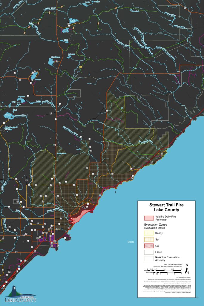
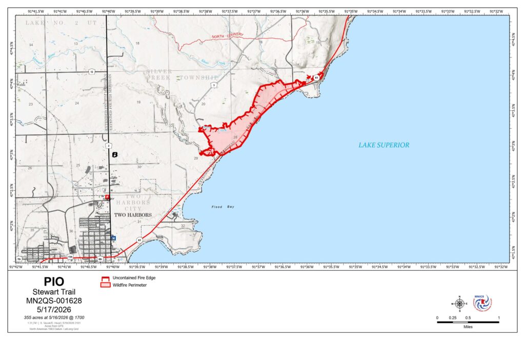
Stewart Trail Fire update Tuesday, May 19, 2026 12:00 PM Emergency Manager- Warren LaPlante
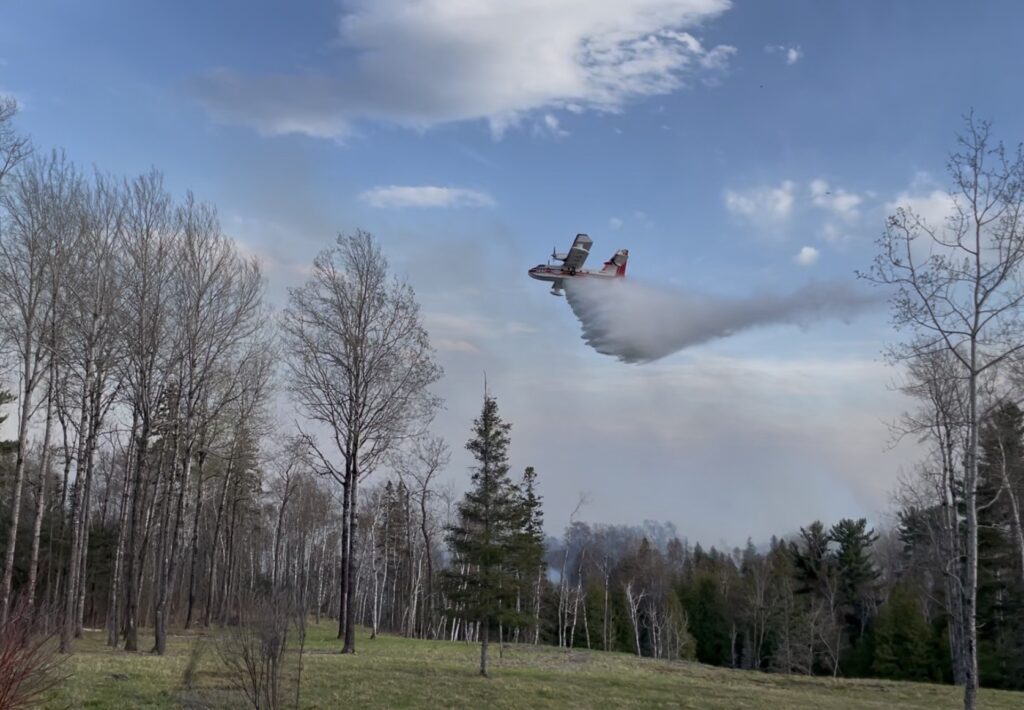
All evacuation zones related to the Stewart Trail Fire have been lifted, and the fire is now reported as 100% contained. Fire personnel will continue monitoring and mop-up operations within the fire area to address any remaining hotspots and ensure public safety.
Highway 61 has fully reopened to traffic, and all other county roads previously closed in association with the fire are now open. Motorists are asked to use caution while traveling through the area and remain alert for firefighters, emergency personnel, heavy equipment, and crews that may still be working along roadways and within the fire area.
Residents and property owners may now return to their homes and properties. Individuals returning to evacuated areas should continue to exercise caution, as fire personnel may still be operating in and around affected locations.
The Lake County Sheriff’s Office would like to thank residents, partner agencies, firefighters, emergency personnel, volunteers, and the public for their patience, cooperation, and support throughout this incident. The coordinated response and support from the community played an important role in protecting lives and property during the Stewart Trail Fire.
Stewart Trail Fire update Sunday, May 18, 2026 10:00 AM Emergency Manager- Warren LaPlante
Property owners within the evacuation area between Stewart River and the Silver Cliff Tunnel will have an opportunity to participate in escorted access to their properties today between 2:00 p.m. and 5:00 p.m.
Property owners must provide proof of residency or property ownership at check-in prior to entry. Acceptable documentation may include: • Driver’s license with matching address • Property tax statement • Utility bill • Other official documentation showing ownership or residency
Check-in will begin at 1:30 p.m. at the Betty’s Pies parking lot staging area, located at 1633 Highway 61, Two Harbors.
The final escorted entry into the evacuation area will depart at 4:00 p.m.
Escorted access will be coordinated by emergency personnel, and all participants must follow instructions from law enforcement and fire officials while in the area.
A Lake County Emergency Alert with this information will be sent to impacted individuals who are signed up for the Lake County emergency alert system. Residents and property owners who wish to receive future emergency notifications can register through the Lake County website.
Please note that conditions may change based on fire activity and public safety concerns.
If any property owners have questions regarding the escorted access process, please contact Chief Deputy Sheriff Tim Luoma at 218-834-8387. However, if your questions can wait until check-in, that would be preferable to help keep phone lines available for emergency operations.
Please visit the Lake County website for continued updates on the fire.
Stewart Trail
Publication Type: News – 05/18/2026 – 09:10
Size: 355 acres Origin: 3 miles north of Two Harbors, Minnesota County: Lake Start Date: May 15, 2026
Cause: Power Line Containment: 62% Structures Lost: 34, including 8 primary and 26 outbuildings
Total Personnel: 77
Today’s Highlight: Firefighters made notable progress securing containment lines and reducing fire activity within the interior fire perimeter. Firefighters acted quickly to knock down one small flare-up deep within the perimeter created by shifting winds. Due to increased containment and successful suppression efforts, evacuation zones have been reduced in areas where threats to public safety have diminished.
Operations: Firefighters have been working tirelessly to assess and strengthen control lines, mopping up at least 125 feet inside southern and western side perimeter and 60 feet inside the eastern perimeter. Flare up areas will continue to be patrolled and monitored. Structure teams completed mopping up around structures, creating protective buffers of 200 feet. Tracked vehicles and crews monitored the integrity of the dozer lines, ensuring the line held up to shifting winds. Overnight, two tracked vehicles and two engines patrolled the perimeter and all structures for flare-ups and hot spots. Firefighters gridded and patrolled the containment line before the rain started.
Planned Activity: Firefighters will continue to patrol and grid, systematically searching within the interior fire area for pockets of heat to be extinguished. Efforts will continue on securing and improving fire lines with hose lays on northern edge and mopping from the perimeter to interior at least 60 feet. Mop up includes checking for lingering heat, wetting down hot spots, extinguishing smoldering stumps, roots, and debris, and removing hazardous snags.
A temporary flight restriction (TFR) is in place. A TFR restricts aircraft from entering the designated area to ensure safety during firefighting operations. Do not fly unauthorized drones near the fire. Remember – If you fly, we can’t!
Closures: Due to impacts from firefighting resources, U.S. Highway 61 is closed between the Stewart River and the Silver Cliff Tunnel. A detour remains between Silver Bay to Two Harbors for those who need to travel around the area. For more information, people can visit http://511mn.org for updates from MNDOT.
The public is asked to follow the detour around Highway 61 and stay out of the closure area for their safety.
Evacuations: Lake County has reduced portions of the evacuation zone, and the Ready, Set, Go notification plan remains in effect. Current evacuation information can be referenced on the Lake County Fire Evacuation | Lake County Atlas Parcel Viewer.
Weather: Today, temperatures in the high 40’s, with northeasterly winds in the morning. Relative humidity up to 80%. Northeasterly winds increase to 6-14mph this evening, gusting to 25mph throughout the night. Precipitation potential increases throughout the evening, with a slight chance of thunderstorms tonight.
Stewart Trail Fire update Sunday, May 17, 2026 3:50 PM Emergency Manager- Warren LaPlante
The Lake County Sheriff’s Office, in coordination with the Minnesota Incident Command System (MNICS) team and the Lake County Emergency Manager, has reduced portions of the evacuation zone related to the Stewart Trail Fire.
The updated evacuation map is available on the Lake County website, and a direct link is provided below. Changes to the evacuation area were made based on the current size, status, and behavior of the fire.
Residents are encouraged to carefully review the updated map to determine the current status of their area. Locations that are no longer within the active evacuation zone have been moved to “SET” status. Residents in these areas should remain prepared to evacuate if conditions change.
The Highway 61 detour remains in effect at this time. Motorists are asked to continue following posted detour routes and avoid the fire area to allow emergency personnel to operate safely.
However, portions of Highway 61will be reopened for local traffic returning to homes in areas that were previously under evacuation orders. Again, Highway 61 will remain closed to through traffic between the Stewart River and the Silver Cliff Tunnel.
Size: 355 acres Origin: 3 miles north of Two Harbors, Minnesota County: Lake Start Date: May 15, 2026
Cause: Under Investigation Containment: 30% Structures Lost: 34, including 8 primary and 26 outbuildings
Total Personnel: 77
Today’s Highlight: Firefighters quickly responded with aircraft and ground crews to a spot fire along the northern perimeter, limiting fire spread even with the high winds and increased fire danger yesterday afternoon.
Operations: Firefighters assessed and strengthened the control lines. This included creating a Two-blade wide dozer line along the western side and cold trailing around the southern hand line, which means they checked for heat and wet down the area. Firefighters worked to contain a spot fire on the northeastern corner of the fire. Numerous aircraft provided water drops. Firefighters were able to get a better assessment of the fire size, and the acreage has been updated to 355 acres. Local fire departments worked on structure protection by mopping up to remove any hot spots within 50 feet around each structure. Crews continued containment and monitoring overnight, watching for flare-ups and areas of heat throughout the entire area.
Planned Activity: Crews continue to strengthen the dozer line and add hose line to areas along the northern perimeter. Structure protection will continue, and crews will increase the area around structures by doing mop-up and removing hot spots 100 feet or more around each structure.
Aircraft will continue to provide assistance with water and fire-retardant drops. A temporary flight restriction (TFR) is in place. A TFR restricts aircraft from entering the designated area to ensure safety during firefighting operations. Do not fly unauthorized drones near the Stewart Trail Fire. Remember – If you fly, we can’t!
Closures: Due to impacts from heavy smoke and firefighting resources, U.S. Highway 61 is closed at County Highway 2 in Two Harbors and at County Highway 106 (West Castle Danger Road) in Castle Danger, Minnesota. A detour has been set up from Silver Bay to Two Harbors for those who need to travel around the area. For more information, people can visit http://511mn.org for updates from MNDOT.
The public is asked to follow the detour around Highway 61 and stay out of the closure area for their safety.
Evacuations: Lake County has implemented the Ready, Set, Go notification plan. Current evacuation information can be referenced on the Lake County Fire Evacuation | Lake County Atlas Parcel Viewer.
Weather: Today, temperatures will be in the upper 40s. The humidity is higher today, around 58 percent. Winds shift to easterly today and will increase with speeds around 8 -17 mph in the morning and 18-21 with wind gusts of 30-35 late afternoon. Rain showers and storms are predicted to bring ¾ – 1 inch of precipitation late afternoon.
Stewart Trail Fire update Sunday, May 17, 2026 9:40 AM Emergency Manager- Warren LaPlante
As of this morning, the fire has remained within the same footprint as yesterday. Conditions continue to be monitored closely. Fire crews continue structural protection efforts, and firefighters remain actively engaged in containment operations throughout the incident area.
At this time, there are no changes to evacuation zones. For public safety, all residences and properties within the evacuation zone remain closed to public access. Re-entry is prohibited until further notice
.If you have questions regarding your property within the evacuation zone, please call the MNICS Public Information line at 218-216-6884 and leave your name and phone number. A coordinated response will be provided as information becomes available.
The Sheriff’s Office is working to contact all property owners whose structures sustained damage. During last evening’s press conference, the Lake County Sheriff reported that 34 structures were damaged, including 8 primary residences.
The shelter at Sonju Arena has been closed at this time. Lake County Public Health remains prepared to reopen shelter operations if conditions warrant it.
Stewart Trail Fire update Saturday, May 16, 20267:45 PM
Stewart Trail Fire update Saturday, May 16, 20262:30 PM Emergency Manager- Warren LaPlante
As of early this afternoon, the fire remained within its current footprint. Conditions continue to be monitored closely as we enter the hottest part of the day and winds remain active. Fire crews are continuing structural protection efforts, and firefighters remain engaged in suppression operations throughout the incident area.
At this time, there are no changes to evacuation zones. For public safety, all residences and properties within the evacuation zone remain closed to public access. Re-entry is prohibited until further notice.
Damage assessment is ongoing. We will provide more information when its available.
Stewart Trail Fire update Saturday, May 16, 2026 10:47 AM Emergency Manager- Warren LaPlante
Firefighters, including local fire departments from around the northland, battled the fire overnight focusing on structural protection and holding the line. Overnight, firefighters were able to get a better assessment of the fire size, and the acreage has been updated to 376 acres.
An initial Evacuation Point, which has turned into a shelter, was established at the Sonju Arena by Lake County Public Health. Red Cross assisted overnight and St Louis County provided informational support.
This morning at 06:00 a.m. a Type III IMT assumed command of the fire situation in Unified Command with Two Harbors Fire Department and Lake County Sheriff.
Lake County has implemented the Ready, Set, Go notification plan. Evacuation zones have been initiated, and the Shirreffs Office went door-to-door in the immediate hazard zone. The evacuation zones map can be found on the Lake County website by clicking on the “Lake County Mapping and Online Parcel Mapping” which is located on the main page, then clicking on the bottom right tab of the map titled fire evacuation.
Due to impacts from heavy smoke and firefighting resources, U.S. Highway 61 is closed at County Highway 2 in Two Harbors and at County Highway 106 (West Castle Danger Road) in Castle Danger, Minnesota. A detour has been set up from Silver Bay to Two Harbors for those who need to travel around the area. For more information, people can visit http://511mn.org for MNDOT updates.
The public is asked to follow the detour around Highway 61 and stay out of the closure area for their safety. Please visit the Lake County website for continued updates on the fire.
Spring Load Restrictions for County highway, roads, and Unorganized Territory (UT) roads will be lifted beginning Friday, May 14, except on the following list of roads:
Cramer Road (CSAH 7, CSAH 8, and CR 705)
Highway 3 (CSAH 3)
Gun Club Road (CSAH 24)
Fors Road (CR 301)
Drummond Grade (CR 131)
Old Drummond Road (UT 10)
Westover Road (UT 34)
Moen Road (CR 123)
Highland Lake Road (UT 47)
We expect the remaining restrictions to be lifted before June.
Please take note that the legal load restriction is governed by the signs posted – if the lost restriction sign is posted, the load restriction is in place.
NOTICE 15th Street (CSAH 27) will be closed to traffic between 7th Avenue (Hwy 61) and 8th Avenue, including the intersection of 15th Street and 8th Avenue (see image attached).
When Beginning: Week of May 18 Ending: July 3 (estimated)
Purpose The closure is necessary for the City of Two Harbors and their contractor to complete improvements on city owned water and natural gas systems.
Traffic Impacts A detour route will be posted on 7th Avenue (CSAH 11), 19th Street, and 14th Avenue (CR 105). 15th Street will remain open to residents between 9th Avenue and 15th Avenue. Access for residents with driveways between 7th Avenue and 8th Avenue will be coordinated with project personnel.
Please contact the City of Two Harbors with any project related questions or concerns.
NOTICE Lake County Highway Department will be closing Airport Road (County Road 111) to through traffic between Waldo Road (County Road 27) and Highway 2 (see image below).
When Beginning: Monday, May 18, 6:00 AM Ending: Friday, May 22, 7:00 PM (anticipated)
Why This closure has been requested by CN rail to facilitate upgrading the west railroad crossing on Airport Road. The tracks and rail crossing surface will be removed and will not be open to highway traffic.
Residential Access: The road will be open to residents and local traffic on either side of the rail crossing closure.
On April 28, 2026, the Lake County Board of Commissioners approved by resolution the adoption of amendments to the Lake County Subdivision Ordinance #9 and Land Use Ordinance #12. The adopted ordinances will go into effect on May 8, 2026.
The County Board resolution and the ordinance amendments, are located below:
NOTICE OF PUBLIC HEARING REGARDING AMENDMENTS TO THE LAKE COUNTY LAND USE ORDINANCE # 12 & LAKE COUNTY SUBDIVISION ORDINANCE #9
Notice is hereby given that the Lake County Planning Commission will conduct a public hearing on Monday, April 20, 2026, at 6:00 PM in the Law Enforcement Center, 613 Third Avenue, Two Harbors, Minnesota, to consider proposed amendments to Lake County Land Use Ordinance #12 and Lake County Subdivision Ordinance #9. All interested persons are invited to attend the public hearing to provide input. Interested persons may submit written comments via email message before 4:30 P.M. Thursday, April 16, 2026 to Tanya.feldkamp@co.lake.mn.us or to the Lake County Environmental Services Department, 601 Third Avenue, Two Harbors, MN 55616, prior to the hearing.
Lake County in conjunction with MN HSEM (Homeland Security and Emergency Management) and the NWS (National Weather Service) sponsor Severe Weather Awareness Week across Minnesota.
As we close out of winter, this is a great time to refresh, remind, and educate everyone on the seasonal severe weather threats and how to avoid them, along with protecting yourself, family, and friends. This is also a great time to create and practice an emergency plan and build a preparedness kit.
During this week, each day will have the following focus topics:
Across Minnesota, the 2026 statewide tornado drills are scheduled for Thursday, April 16 at 1:45 p.m. and 6:45 p.m. CDT.
Please take a few moments to visit the following link for additional severe weather preparedness information at Severe Weather Awareness Week.
To learn more about specific Lake County emergency preparedness opportunities, please come to visit us on April 26th for “Survive This! Lake County Emergency Resilience” at the Two Harbors High School from 1-3 p.m.
Lake County is rolling out new wildfire evacuation zones and we are encouraging all residents, businesses, and property owners to become familiar with the updated zones. As an improvement to protecting our residents this effort is directly related to last years Camphouse Fire.
What has changed: The zone sizes have been dramatically reduced allowing us to provide for a better readiness state through our mass notification and GIS systems. The previous zones were so large that realistically there could be all evacuation three stages in one zone, thus it didn’t provide a true evacuation readiness state for those closest to the fire hazard.
What has not changed: The three evacuation stages: READY, SET, and GO.
READY means “there is a potential for evacuation” SET means “be prepared to evaluate in a moments notice” GO means “evacuation immediately”
Additional information on wildfire readiness and Firewise programs:
On March 24, 2026, the Lake County Board of Commissioners approved by resolution the adoption of amendments to the Lake County Cannabis Ordinance #29. The adopted ordinance will go into effect on April 3, 2026.
Please review the County Board resolution and the ordinance amendments attached to this announcement.
Lake County offices plan to remain open on Friday, March 13. Most departments will be operating with reduced staff due to the expected weather and road conditions. If you have county business to conduct, please contact the appropriate department before traveling. Residents are encouraged to delay arriving until weather conditions improve and roads have been cleared, if possible. Thank you for your patience and understanding.
Lake County property notices will be arriving in your mailbox soon. What to expect: your 2026 Property Tax Statement for Taxes Payable in 2026 and your 2026 Valuation Notice for Taxes Payable in 2027. Notices are mailed together in the same envelope. Be sure to review each notice for your property.
2026 property tax payments are due May 15 and October 15 for most properties. Visit the county website or scan the QR code below to see updated payment options.
2026 Valuation Notices contain your properties classification and estimated market value for your taxes in 2027. The time to review this information is now. Contact your assessor with questions or concerns. The Notice lists meeting dates and information to discuss or appeal your value and classification.
The property tax cycle in Minnesota follows three steps:
Step 1: Valuation and Classification Notice (March). The Assessor determines the estimated market value and classification of each property for the following year’s property taxes. Property owners are provided with an opportunity to review information and attend local or county board of appeal meetings to discuss or appeal their value and classification. Assessments are final after the meetings and appeal process is complete.
Step 2: Proposed Tax Notice (November). Local taxing districts set their budgets for the following year and propose their needed tax levy. Based upon the assessment provided by the assessor and proposed levies, an estimate of next year’s tax is sent to property owners. Public budget meetings are held for residents to provide input on proposed budget and levies. Final levies are set after public meetings are held.
Step 3: Property Tax Statement (March). Property taxes are calculated using the final assessment and levies. A statement is sent to each property owner showing the amount and dates property tax is due.
State law provides the form and content of each property notice, with a box in the upper right corner indicating the notice’s step in the tax cycle.
Over the past few days, we have received several great questions and would like to share the following.
Please stay tuned herefor all the latest updates and information regarding this project.
What have we completed already: Over the weekend, we have completed a few system configuration updates and working on many more. Some of the most important changes include detailing system grouping/types (residential, business, etc.) and have also begun organizing personal accounts into some of those groups/types. This effort will greatly enhance our community alerting for those most impacted by an incident.
Why is this important! There are thousands of individual accounts in the Lake County Emergency Alerts System, and we want to ensure that we have the right information and grouping types to ensure we are prioritizing those most impacted by an event, especially for those life safety incidents.
What’s Next: We will continue to review and update record type configurations (residential, business, etc), along with organizing individual accounts. We will also be updating the portal registration directions to clarify the information we are asking for if not included in a drop box, such as home, business, cabin, property, etc. The next step/phase after that, we will be asking everyone with an account(s) to log in to review, validate, and update their contact information. This will include reviewing for duplicate accounts and encouraging separate “static locations” for respective residential and business purposes.
To register or to review your current profile, you may get there from several directions. -There is a link on the main website, just above this section, -There is a link under the Emergency Management Department website page, or -Cut and paste this link into your browser: https://member.everbridge.net/453003085619442/login
I ask those that are newly registering, once logged in to please fill in all informational blocks as there has already have been system updates; or if you already have an account, please log in to review, validate, and update any contact information that has changed, along with the new informational blocks that have been added.
We have also received several additional questions over the last week, and I would like to take a few moments to answer a few:
Lake County is and will continue to reach out to municipalizes ensuring, we as a team, are informing the citizens and businesses within our county, as appropriate, on events impacting life-safety, such as severe weather/storms, power outages, wildfires, and need for evacuations or sheltering. Lake County will also be kicking off several additional large projects, the County Emergency Operations Plan (EOP) and Community Wildfire Prevention Plan (CWPP) updates and rewrites. Both of these plans work hand-in-hand and will tie our county-wide communities together for support and response.
Everbridge is the same platform the county has used in the past. We are updating the system configurations and contact information to better communicate and conduct community outreach during some of the events and incidents listed above. This is why it is important for all of us to do our part to update and maintain your personal contact information. So, if and when that day occurs, we can send “the right message, to the right people, at the right time”.
Thank you, Warren LaPlante Lake County Emergency Management, Director
NOTICE OF PUBLIC HEARING REGARDING AMENDMENTS TO THE LAKE COUNTY LAND USE ORDINANCE # 12, LAKE COUNTY CANNABIS ORDINANCE #29, & LAKE COUNTY SUBDIVISION ORDINANCE #9
Notice is hereby given that the Lake County Planning Commission will conduct a public hearing on Monday, March 16, 2026, at 5:30 PM in the Law Enforcement Center, 613 Third Avenue, Two Harbors, Minnesota, to consider proposed amendments to Lake County Land Use Ordinance #12, Lake County Cannabis Ordinance #29, and Lake County Subdivision Ordinance #9. All interested persons are invited to attend the public hearing to provide input. Interested persons may submit written comments via email message before 4:30 P.M. Thursday, March 12, 2026 to Alexandra.Campbell@co.lake.mn.us or to the Lake County Environmental Services Department, 601 Third Avenue, Two Harbors, MN 55616, prior to the hearing.
Notice of intended use is hereby give by Lake County to use FY2024 – 2025 Title III funds under Public Law 119-58 “Security Rural Schools and Community Self-Determination Act” (reauthorized in 2025) through FY2028 to:
carry out activities under the Firewise Communities Program to increase protection of people and property from wildfires
reimburse the County for search and rescue and other emergency services performed on federal lands, including firefighting and law enforcement patrols
cover training costs and equipment purchase directly related to emergency services described about, and
develop and carry out Lake County Community Wildfire Protection Plan.
The intended use of this funding is open for public comment for a period of 45 days from the publication notice and will be on the Lake County Board of Commissioners agenda approximately 2 weeks upon public comment period closeout. Comments much be submitted in writing and received at the Commissioner’s Office, 616 Third Ave, Two Harbors, MN 55616 or the Emergency Management Office, 601 Third Ave, Two Harbors, MN 55616. For information, contact Warren LaPlante, Emergency management Director at 218-510-0624 (warren.laplante@co.lake.mn.us) or Matt Huddleston, Lake County Administrator at 218-834-8320 (matthew.huddleston@co.lake.mn.us).
Lake County will be updating and verifying its emergency alert system in the coming months. The county uses a platform called Everbridge and its moto is to provide, “the right message, at the right time, to the right people.” When seconds count, the system delivers real-time alerts through text, phone, and/or email to provide critical information during an emergency. This information may include: the location of and respective emergency updates; if needed, evacuation orders and instructions; if determined, sheltering-in-place instructions; and where to stay tuned for additional information.
The Lake County Emergency Management department will conduct a multi-phase update including system configuration improvements, notification process reviews, participant (residential/business) verification, and annual testing. Progress updates and instructions will be shared through the county website and official social media.
Enrollment is optional but for public safety, residents and businesses are still strongly encouraged to register or update their information during this period.
Winter is just around the corner and are you prepared?
November 17th to the 21st is Minnesota Winter Hazard Awareness Week. This is an opportunity to begin your and your family’s preparation for what will lie ahead: cold temperatures, windy days, icy roads, and slippery sidewalks.
Lake County Emergency Management, in partnership with Lake County’s Public Health, Sheriff’s Office, Highway Department, and the Safety Office, along with the Minnesota Department of Emergency Management and Public Safety have complied timely seasonal information to increase your awareness and preparation.
This will be Lake County’s final situation update.
The Crosby Fire has remained at approximately 300 acres for the last several days and approximately 95% contained. The fire location is still primarily within the George H. Crosby Manitou State Park.
MN DNR has determined the cause of the fire to be lighting.
The Superior Hiking Trail will open on Thursday, 16 Oct, 08:00 am.
On behalf of the county residents and staff, and our visitors, we would like to thank all the responders and support staff on doing a wonderful job to control the fire, protect our residents and their properties, along with our forests.
The Crosby Fire is approximately 300 acres and approximately 70% contained. The fire location is still primarily within the George H. Crosby Manitou State Park.
MN DNR has determined the cause of the fire to be lighting.
MN DNR remains lead agency with support from the US Forest Service. Lake County Sheriff’s Office and Emergency Management department are monitoring the situation and working with the MN DNR.
Based upon the location of the fire at this time, there are no immediate threats to residents or permanent residential structures.
We are asking for the public to stay clear of the area allowing our responders a safe environment to suppress the fire and for your personal safety.
Portion of the Superior Hiking Trail from the Caribou Falls State Wayside Rest along Minnesota State Highway 61 to the Lake County Road 7 (Cramer Road) access points remain closed. The remainder of the state park remains open
Please follow the situation through the Lake County website, both the Lake County and Lake County Sheriff’s Office Facebook sites, MN DNR, and the MNICs press release section. If the situation escalates, we will send out emergency notifications as appropriate through our county alerts program.
The Crosby Fire is approximately 50 acres within the George H. Crosby Manitou State Park. The park is a wilderness area with tough terrain.
MN DNR is lead agency with support from the US Forest Service. Lake County Sheriff’s Office and Emergency Management department are monitoring the situation and working with the MN DNR.
Based upon the location of the fire, there are no immediate threats to residents or permanent residential structures.
We are asking for the public to stay clear of the area allowing our responders a safe environment to suppress the fire and for your personal safety.
Please follow the situation through the Lake County website, both the Lake County and Lake County Sheriff’s Office Facebook sites, MN DNR, and the MINICs press release section. If the situation escalates, we will send out emergency notifications as appropriate through our county alerts program. Lake County Emergency Management
Lake County will be having an online auction at publicsurplus.com from 10:00 AM on Monday, November 3, 2025 through 1:00 PM on Wednesday, December 3, 2025.
Northland Constructors will close 7th Street and Waterfront Drive at 6th Avenue in Two Harbors over the next 4-6 weeks. The tentative schedule for the closures follows: 7th Street Closure at 6th Avenue: Begin: Monday 9/29 End: Friday 10/17 Alternate Route: Waterfront Drive Waterfront Drive Closure at 6th Avenue: Begin Monday 10/20 End: Friday 10/31 Alternate Route: 7th Street & 5th Street Both streets will be closed at 6th Avenue but remain open to Local Traffic to the alleys and driveways on the north and south side of the 6th Avenue intersection. Work to be completed includes city utilities, storm sewer, new curb, sidewalk and pavement.
Preparedness Starts at Home. September is National Preparedness Month and there is no better time than now to prepare yourself and family by taking a few steps to help your family, pets, neighbors, and communities.
The goal for preparedness begins with four key actions: -Know the different types of emergencies you may encounter and what would be your response -Make a family plan -Build an emergency supply kit -Get involved in your community by taking action to prepare for emergencies
When setting up your plan, consider any unique needs, where you live, where your family spends a lot of time (school, work, etc), do you have pets, routes of possible travel, how to evacuate from your home, do you take special medication, any other special needs.
Your plan should include: -Family emergency plan(s) that includes important information, such as: contact information, medical providers/doctors, medications, insurance information, location to safeguard this information, communications plan -Know where you could go before something happens, such as a meeting location(s) depending on the situation, how are you going to communicate with each other on your plan -Have a home escape plan and meeting location in case of a home fire -Pets are part of our family, include them in your family plan –Build a go-kit. You kit should include enough supplies to support your family for several days: water, food, medicine, a comfort toy for your child, radio, flashlight, etc. -When emergency strikes, have multiple ways to get alerts, include items such as a NOAA radio, National Weather Service (NWS) phone apps, local news links, the Lake County Emergency Alerts program (click here to register).
To assist you on your planning, please visit READY.GOV right now and follow the Lake County Emergency Management website (soon under re-development).
If you have any immediate questions, please contact Warren LaPlante, Lake County Emergency Management Director, email: warren.laplante@co.lake.mn.us
Property Tax due dates are May 15 and October 15 of each year. (If the 15th is a Saturday or Sunday, taxes are due on the following Monday)
Lake County has a drop box available in front of the Law Enforcement Center at 613 3rd Ave. There is a sign on the drop box indicating that property tax payments are being accepted.
Taxpayers can view or print their current or delinquent tax statements at any time using the website parcelinfo.com.
Taxes can be paid in person, by mail, drop box or online.
Lake County Highway 2 between Forest Highway 11 (Lake County Road 15) and Minnesota Hwy 1 (MN 1) is scheduled to reopen to traffic beginning on Thursday, August 21.
Travelers can expect reduced travel lane and shoulder widths, and rough road conditions, with sections of unpaved road, grooved pavement surfaces, and active road construction work between the White Pine Picnic area near Upland Trail and the Greenwood Lake Public Water Access point (boat launch). Motorcycle travel is not recommended. During daylight hours, travelers can expect one-lane road conditions under traffic flagger control throughout the work zone. Delays of up to 15 minutes should be expected. Work is scheduled to continue through early October.
Please reduce speed and travel safely through the work zone and let’s make sure everyone, including our construction workers and onsite staff, gets home or to their destination safely.
KGM Contractors will be completing work on the new box culvert at Greenwood Creek this week and will be moving to Murphy Creek near Upland Trail beginning Monday, 7/28.
IMPORTANT: Access to Upland Trail/Whyte Road and to all points north along Highway 2 will need to be via MN Highway 1, starting Monday, 7/28. There will be no access across Murphy Creek, south of Upland Trail, beginning Monday 7/28. Highway 2 will be closed at the White Pine Picnic Area. Access across Greenwood Creek will be open.
Notice of Amendments to the Lake County Subsurface Sewage Treatment System Ordinance #11
Date: June 25, 2025 FOR IMMEDIATE RELEASE Contact: Lake County Environmental Services Department, planningandzoning@co.lake.mn.us or 218-834-8325
On June 24, 2025, The Lake County Board of Commissioners approved by resolution, adoption of amendments to the Lake County Subsurface Sewage Treatment System Ordinance #11. The adopted ordinance will go into effect on July 4, 2025.
Please review the County Board resolution and the ordinance amendments, which will be located at www.co.lake.mn.us and contact the Lake County Environmental Services Department if you have questions.
Notice of Amendments to theLake County Comprehensive Plan and Land Use Ordinance #12
Date: June 25, 2025 FOR IMMEDIATE RELEASE Contact: Lake County Environmental Services Department, planningandzoning@co.lake.mn.us or 218-834-8325
On June 24, 2025, The Lake County Board of Commissioners approved by resolution, adoption of amendments to the Lake County Comprehensive Plan and Land Use Ordinance #12. The adopted ordinance will go into effect on July 4, 2025.
Please review the County Board resolution and the ordinance amendments, which will be located at www.co.lake.mn.us and contact the Lake County Environmental Services Department if you have questions.
The Lake County Highway Department will end spring load restrictions (SLR) on Monday, May 12, 2025 at 12:01 AM EXCEPT for the following roads:
CR 131 Drummond Grade
CSAH 7 (Cramer Road)
CSAH 8 (Cramer Road)
CSAH 24 (Gun Club Road)
CR 301 (Fors Road)
CSAH 3 (Highway 3)
Ending dates for spring load restrictions are variable and based on how weather is affecting roadway strength. The sign erected on the roadway governs the load limit in effect.
Property Tax due dates are May 15 and October 15 of each year. (If the 15th is a Saturday or Sunday, taxes are due on the following Monday).
Lake County has a drop box available in front of the Law Enforcement Center at 613 3rd Ave. There is a sign on the drop box indicating that property tax payments are being accepted.
Taxpayers can view or print their current or delinquent tax statements at any time using the website parcelinfo.com.
Taxes can be paid in person, by mail, drop box or online.
The Lake County Board of Commissioners is seeking individuals interested in volunteering on the Lake County Planning Commission or Board of Adjustment. These commissions meet once per month and make decisions regarding land development and environmental issues. Applicants must reside in Lake County, but preferably outside any municipal corporate limits. Please contact the Lake County Environmental Services Department at the Lake County Courthouse, 601 Third Avenue, Two Harbors, MN 55616, email planningandzoning@co.lake.mn.us , or call 218-834-8325 for more information.
Please submit a resume or application by May 1, 2025.
The Lake County Board of Commissioners has designated The Lake County, Minnesota Website as the official publication location for any transportation project advertisement for bids. Bid advertisements can be found at this link: Construction Projects – Lake County, MN
Notice is hereby given that the Lake County Board of Commissioners will hold a Public Hearing on Tuesday, December 17, 2024, at 2:30 P.M. at the Lake County Service Center, Split Rock River Room, 616 Third Avenue, Two Harbors, Minnesota, 55616.
The purpose of the public hearing is to receive comments on a proposed Lake County Cannabis Ordinance.
Summary of the proposed Lake County Cannabis Ordinance:
Prohibits public use of cannabis
Limits registrations of cannabis retail operations
Prohibits cannabis businesses within certain distances from schools, day care providers, residential treatment facilities and attractions within public parks
Limits hours of operations
Provides zoning framework for cannabis businesses and hemp businesses
Provides regulations for cannabis events
Establishes requirements on sale of low potency hemp
A draft of the proposed ordinance is available at the Lake County Service Center, Office of the County Administrator, 616 Third Avenue, Two Harbors, Minnesota, 55616. All persons interested are invited to attend the Public Hearing. Written comments may be submitted to clerk.board@co.lake.mn.us or by U.S. Postal Service mail to Lake County Service Center, Office of the County Administrator, 616 Third Avenue, Two Harbors, Minnesota, 55616
Lake County has completed an updated draft of its Hazard Mitigation Plan (HMP) and is now seeking public feedback. Like all Minnesota counties, Lake County is vulnerable to a variety of natural hazards such as tornadoes, windstorms, severe winter storms, flooding, drought, and extreme temperatures, which can threaten the loss of life and property in the county. Planning for natural disasters minimizes the impact of events that can cause vast economic loss and personal hardship.
The Small Business Association offers low interest loans for homeowners and businesses that have been impacted by disasters. In June, Lake County saw widespread flooding that impacted many homeowners. To apply for an SBA loan, please call or register online.
Property Tax due dates are May 15 and October 15 of each year. (If the 15th is a Saturday or Sunday, taxes are due on the following Monday).
Lake County has a drop-box available in front of the Law Enforcement Center at 613 3rd Ave. There is a sign on the drop box indicating that property tax payments are being accepted.
Taxpayers can view or print their current or delinquent tax statements at any time using the website parcelinfo.com.
Taxes can be paid in person, by mail, drop box or online.
A FEMA/State Disaster Recovery Center will open Friday, August 16, 2024, to help residents kickstart their recovery after the severe storms and flooding of June 16 – July 4.
After Request from Governor Walz, Federal Disaster Declaration Expanded to Include Individual Assistance for Minnesotans Impacted by Flooding
Governor Tim Walz today announced that Minnesotans in 19 counties working to recover from this year’s flooding can now request individual assistance from the Federal Emergency Management Agency (FEMA) to help recover from losses they suffered. The declaration will provide resources to reimburse individuals and communities for debris removal, emergency protective measures, and repair and replacement of damaged infrastructure.
The individual assessment declaration is the next step in the state’s ongoing dedication to assisting affected communities.
While individual assistance cannot compensate for all losses caused by a disaster, it is a significant step in helping people meet their basic needs and supplement disaster recovery efforts.
The following counties are currently part of the declaration: Blue Earth, Cook, Cottonwood, Faribault, Freeborn, Goodhue, Itasca, Jackson, Lake, Le Sueur, Mower, Nicollet, Nobles, Rice, Rock, St. Louis, Steele, Waseca, and Watonwan.
In the coming days, FEMA, in partnership with HSEM, will establish disaster recovery centers to assist people in navigating the process and house state agency representatives to ensure individuals and businesses understand all the programs that are available. More information on how to access these centers will be forthcoming from FEMA.
In the meantime, individuals in the declared counties are encouraged to create an application online by visiting disasterassistance.gov/. You can also call the FEMA Helpline at 800-621-3362. Specialists are available seven days a week from 7 a.m. to 11 p.m. ET.
For Lake County residents, the disaster recovery center will most likely be in Virginia, where individuals can apply for reimbursement or funds to repair damages. The dates and times of the center will be updated when more information is available. If you have any questions or concerns, please contact Matt Pollmann, Lake County Emergency Manager, at 773-844-6449.
Lake County is excited to start its Public Land Survey corner maintenance and restoration project. With the help of Bolton & Menk, we’re going to locate and/or establish the position of all the section corners in Townships 52-11 & 53-11.
On June 6, 2024, at 1546 hours (3:46 pm), Lake County Dispatch received a call from a female party whose husband was in the BWCA with 3 other men. She indicated that she received a call from Focus Point International stating that they had received an SOS from a locator from that group. Coordinates from the locator placed the group on Malberg Lake within the BWCA, and there was no information available as to the type of emergency that may be occurring due to the locator not having messaging capability.
Based on the limited information, the US Forest Service was contacted to see if a Beaver could fly in with a Lake County Deputy and medical personnel to check on the group. At approximately 1747 hours, initial contact was made with the group. The group indicated that a 69-year-old member of their group was last seen at 1130 that morning when he went for a walk and had not returned.
Based on the remote location and time of day, a ground search was planned utilizing Lake County Search and Rescue personnel, which would start the following morning.
The Minnesota State Patrol was requested and with the assistance of their fixed wing aircraft were able to locate the missing party some distance away from the location of the group. The missing party was actively trying to communicate with the aircraft.
The decision was made to activate the Minnesota Aviation Rescue Team (MART) through the Minnesota State Patrol to assist in rescuing the missing party.
At approximately 2342 the missing party was rescued and transported via helicopter to the Ely airport where he was checked out by medical personnel.
The Lake County Sheriff’s Office would like to thank the Minnesota State Patrol, US Forest Service, Minnesota Aviation Rescue Team and Ely Ambulance for their assistance.
Basswood Lake, Boundary Waters Canoe Area, Water Emergency
On June 4, 2024 at 1536 hours (3:36 pm), Lake County Dispatch received a call of a Boy Scout group with an overturned canoe on Basswood Lake. Four juveniles and one adult male had made it to an island, while four more juveniles and another adult male were on the mainland. No injuries were reported at this point.
Ontario Provincial Police (OPP) notified Dispatch that they also had been contacted by the campers and advised them that rescue plans were in the works, and the group was advised to stay put. OPP advised that they would be on standby if their assistance was needed, but due to the weather they were unable to assist with any air assets.
Rescue units were dispatched and USFS was contacted for assistance. Due to the approaching storm front, it was decided that for the safety of all, rescue crews would go in to assist the following morning.
At 1759 hours (5:59 pm), OPP notified Dispatch that they had been in contact with the adult via Garmin and were advised that the campers had been rescued and they no longer needed assistance from law enforcement or rescue.
No additional information is available at this time.
A male was discovered deceased in the Baptism River on May 12th.
On May 12, 2024 at 1144 hours (11:44 am), Lake County Sheriff’s Office responded to a report of a body found in the Baptism River in Tettegouche State Park. At 1518 hours (3:18 pm) when Lake County Deputies and Rescue had retrieved the body from the river, the decedent’s identity was unknown.
On May 13, 2024 at approximately 1800 hours (6:00 pm), some clothing and a wallet, belonging to Zachery Bulen of Finland, were located at the base of Illgen Falls north of Tettegouche State Park. A positive identification was confirmed with fingerprints by the Minnesota BCA.
Agencies assisting the Lake County Sheriff’s Office during this incident were Lake County Rescue, Minnesota DNR, Tettegouche State Park, Silver Bay Police, and Minnesota Bureau of Criminal Apprehension (BCA).
At this time, a cause of death has not been determined and the incident is still being investigated.
A male was discovered deceased in White Iron Lake over the weekend.
On Sunday, May 26, 2024 at 1406 hours (2:06 pm), the Lake County Sheriff’s Office received a call from a party who had seen a body floating on the water on White Iron Lake.
At approximately 1437 hours (2:37 pm), Lake County Sheriff’s Office arrived on scene. Also responding to the scene were the U.S. Forest Service, DNR, U.S. Border Patrol, and Morse-Fall Lake Fire Dept. Contact was made with the reporting party who stated they had seen an unoccupied boat banging on the rocks and then noticed the body floating on the water.
Initial investigation did not indicate any accident had occurred and the victim was not wearing a lifejacket at the time of the incident.
The Medical Examiner Investigator preliminarily ruled it an accidental drowning and the incident is still an active investigation pending final results.
The victim has been identified as 54 year-old Duane Kreuger from St. Louis, Missouri.
The Lake County Highway Department will end spring load restrictions (SLR) on Monday, May 6, 2024 at 12:01 AM EXCEPT for the following roads:
UT50 Murphy Lake Rd
UT51 Tikkanen Road
UT52 Kari Road
UT53 Rikala Road
UT54 Koski Road
UT55 Ahlgren Road
UT56 Etelainen/Rinne Road
UT 57 Grondahl Road
UT58 Kamarainen Road
UT59 Nelson Road
CR118 Toivonen Road
Ending dates for spring load restrictions are variable and based on how weather is affecting roadway strength. The sign erected on the roadway governs the load limit in effect.
Property Tax due dates are May 15 and October 15 of each year. (If the 15th is a Saturday or Sunday, taxes are due on the following Monday).
Lake County has a drop-box available in front of the Law Enforcement Center at 613 3rd Ave. There is a sign on the drop box indicating that property tax payments are being accepted.
Taxpayers can view or print their current or delinquent tax statements at any time using the website parcelinfo.com.
Taxes can be paid in person, by mail, drop box or online.
The Lake County Sheriff’s Office is looking to implement body worn cameras in spring/early summer of 2024. According to Minnesota Statute 626.8473 subd.2. Public Comment, all “local law enforcement must provide for public comment before it purchases OR implements a portable recording system. At a minimum, the agency must accept public comments submitted electronically or by mail, and the governing body with jurisdiction over the budget of the law enforcement agency must provide for public comment at a regularly scheduled meeting.”
Public Comment
The written draft policy will be available for public comment starting April 1st, 2024 through April 15th,2024. If you would like to make comments, please submit them via email to sheriff@co.lake.mn.us
If you wish to submit your comments by mail, please send them to the following address:
Lake County Sheriff’s Office
613 3rd Ave
Two Harbors MN, 55616
Ref: BWC Comment
The body worn camera policy will be also available for comment at the Lake County Board of Commissioners meeting on Tuesday, April 23rd, at 2 p.m., in the Split Rock River Room on the main floor of the Lake County Service Center, 616 Third Avenue, Two Harbors, Minnesota.
The Draft BWC Policy will be made available to view on the Lake County website: https://www.co.lake.mn.us.
Property Tax due dates are May 15th and October 15th of each year. (If the 15th is a Saturday or Sunday, taxes are due on the following Monday).
Lake County has a drop-box available in front of the Law Enforcement Center at 613 3rd Ave. There is a sign on the drop box indicating that property tax payments are being accepted.
Taxpayers can view or print their current or delinquent tax statements at any time using the website parcelinfo.com.
Taxes can be paid in person, by mail, drop box or online.
On Thursday, August 24, 2023 at 07:53 hours, the Lake County Sheriff’s Office received a call of a one-vehicle crash on Fernberg Road near Summer Home Road.
The deceased driver, and only occupant of the vehicle, was 62-year old Robert Oliva, who had been residing in the Ely area. The accident is currently under investigation.
Responding to the scene were the Lake County Sheriff’s Office, Lake County Highway-Fall Lake, Ely Area Ambulance, and Morse-Fall Lake Fire Department.
The Recount for the Lake County Special Commissioner election will be held Friday, August 18, 2023 at 9:00am in the Lake County Law Enforcement Center (613 3rd Ave. Two Harbors, MN 55616).
The Canvass Board for the Lake County Special Commissioner election will be held on August 10, 2023 at 10:00am in the Lake County Law Enforcement Center (613 3rd Ave. Two Harbors, MN 55616).
Regular Meeting of the Lake County Board of Commissioners New Date and Time: 10:00 AM on Wednesday, July 26, 2023. Rescheduled Location: Lake County Highway Department, Highway 2 Meeting Room, 1513 Highway 2, Two Harbors, Minnesota
The Lake County Board of Commissioners’ regular meeting that was scheduled for Tuesday, July 25, 2023, has been canceled. This meeting is rescheduled to a different date, time and location, as follows. The Lake County Board of Commissioners will meet at 10:00 a.m. on Wednesday, July 26, 2023, at the Lake County Highway Department, Hwy 2 Meeting room, 1513 Highway 2, Two Harbors, Minnesota.
UPDATE: The two males who drowned after cliff jumping into Lake Superior have been identified as Austin Henning, 18 years old, of South St. Paul, and Maximillion Williams, 18 years old, of Inver Grove Heights.
The Minnesota DNR also responded to the scene.
On Sunday, June 25, 2023 at 13:25 hours, the Lake County Sheriff’s Office received a call about two parties cliff jumping at Black Beach in Silver Bay who were seen struggling to swim in Lake Superior.
Lake County Search & Rescue responded and assistance was requested from St. Louis County Rescue Squad and the US Coast Guard. The US Coast Guard dispatched a boat from their Bayfield (WI) station as well as a helicopter to assist with the search.
At around 18:12 hours, the body of a male was located and pulled out of the water. At around 19:39 hours, the body of a second male was located and pulled out of the water. The identities of the two males will be released once family notifications are complete.
Responding to the scene were the Lake County Sheriff’s Office, Lake County Search & Rescue, Lake County Ambulance, Silver Bay Police Department, Silver Bay Fire Department, St. Louis County Sheriff’s Office, St. Louis County Rescue Squad, and the US Coast Guard.
NOTICE OF RESCHEDULED PUBLIC HEARINGS FOR INTERIM USE PERMITS IN LAKE COUNTY, MINNESOTA
Notice is hereby given that, due to the recent adoption by the State of MN recognizing June 19 (Juneteenth) as an official holiday and subsequent approval by the Lake County Board of Commissioners, the Lake County Planning Commission Meeting previously scheduled and noticed for June 19, 2023 was canceled.
The previously noticed hearings, each of which are for renewal of interim use permits for short-term vacation rental properties, include: Wanda Widen and Brian & Cynthia Foyt, for the property at 2237 7th Ave, Two Harbors, MN 55616; Sharon Erickson-Ropes&Milton Ropes, for the property at 726Old North Shore Road, Two Harbors; and Noah Wolf & Jane Connors for the property at 7004 Airbase Rd, Finland, MN 55603. These hearings will instead be heard on Monday, June 26, 2023 at the Lake County Highway Department building beginning at, respectively: 2:15 pm, 2:30 pm, and 2:45 pm. Public comment period will remain open until close of business on Wednesday, June 21, 2023. Any questions or concerns should be directed to: Lake County Planning and Zoning, 601 3rd Ave, Two Harbors, MN. 55616. Email: planningandzoning@co.lake.mn.us
Notice of Amendments to the Vacation Rental Home Regulations in the Lake County Land Use Ordinance #12
Date: May 12, 2023 FOR IMMEDIATE RELEASE Contact: Matt Huddleston, County Administrator
On May 9, 2023, The Lake County Board of Commissioners approved by resolution, adoption of amendments to Sec. 27.06 A, Vacation Rental Home Requirements in Lake County Land Use Ordinance #12. The amendments to the ordinance will go into effect on May 28thwhen Interim Ordinance No. 19-2, imposing a moratorium on Vacation Rental Homes (VRH) through interim use permits (IUP), expires.
May 29th is Memorial Day, and Lake County will be closed, therefore, Lake County will begin accepting Interim Use Applications for vacation rental homes on Tuesday May 30th at 8:00am.
Generally, the amended ordinance imposes a cap or limit to the amount of VRHs in residential zoning districts in Unorganized Territory #2, Unorganized Territory #1, Beaver Bay Township, Crystal Bay Township, Silver Creek Township, Stony River Township and Knife River. Please review all of the ordinance amendments, which will be located at www.co.lake.mn.us and contact the Lake County Environmental Services Department if you have questions.
Lake County Veterans Services assists Veterans, their families, caregivers, and survivors with benefits related to military service. Updated laws and expanded benefits have resulted in a significant increase in requested services above the current capacity of the available resource. While working to implement a permanent solution and in order to preserve the highest level of service possible, the difficult decision has been made to temporarily limit the availability of the County Veterans Service Officer (CVSO). This will provide dedicated time to process the backlog of claims and requests.
The Veterans Services office will be temporarily closed from 05/22/2023 to 06/02/2023. In-person services will not be available, and phone and email responses will be delayed. Everyone is encouraged to continue submitting requests and questions via the Veterans Services phone number and email address. Please use the available voicemail or email to leave a message.
On 06/05/2023, the office will reopen on Mondays, Wednesdays, and Fridays for in-person services (appointments are strongly encouraged). Services will be limited Tuesdays and Thursdays allowing the CVSO to continue processing the backlog of claims and requests. The days may vary depending on holidays or other scheduling conflicts. The temporary, modified operating days will be in effect while solutions are being put into place to continue providing the highest quality of services our Veterans have earned and expect.
Your patience and understanding are truly appreciated during this transitional and temporary period.
The Lake County Planning Commission will conduct a public hearing on Thursday, April 27, 2023, at 6:00 PM in the Lake View Conference Center, 325 11th Avenue, Two Harbors, Minnesota, for the purpose of considering proposed amendments to Sec. 27.06 A. Vacation Rental Home requirements in Lake County Land Use Ordinance #12. Interested persons may submit written comments by 4:30 pm on Monday, April 24, 2023 via email message to Melissa.McIntyre@co.lake.mn.us or to the Lake County Environmental Services Department, 601 Third Avenue, Two Harbors, MN 55616, prior to the hearing.
Virtual attendance option available for listening purposes only. Topic: Vacation Rental Home Public Hearing Regarding Proposed Ordinance Amendments Time: Thursday, April 27, 2023 06:00 PM
Property Tax due dates are May 15th and October 15th of each year. (If the 15th is a Saturday or Sunday, taxes are due on the following Monday).
Lake County has a drop-box available in front of the Law Enforcement Center Building at 613 3rd Ave. There is a sign on the drop box indicating that property tax payments are being accepted.
Taxpayers can view or print their current or delinquent tax statements at any time using the website parcelinfo.com.
Taxes can be paid in person, by mail, drop box or online.
North Shore State Trail / Airbase Road, Snowmobile Fatality
March 7, 2023
On 3-04-2023 at 10:58 AM, Lake County Dispatch received a call reporting a snowmobile accident on the CJ Ramstad/North Shore State Trail snowmobile trail crossing on the Airbase Road in Finland.
After being transported by ambulance and rescue to the LifeLink landing zone at the Clair Nelson Center in Finland, the victim, a 52-year old female named Kellie Brickson of Hermantown, was pronounced dead.
Responding to the scene were the Lake County Sheriff’s Office, Lake County Rescue Squad, Lake County Ambulance and LifeLink air medical
On 2-13-2023 at 6:07 AM, Lake County Dispatch received a call about a collision on Highway 2 at the Gun Club Road north of Two Harbors. The crash involved a semi truck and a passenger vehicle. The driver of the semi, a 71-year old male, denied medical attention. The driver of the passenger vehicle, a 54-year old female, was extricated from the vehicle by the Two Harbors Fire Department and transported to St. Luke’s by Lake County Ambulance with non-life threatening injuries. The accident is currently under investigation by the Lake County Sheriff’s Office with assistance from the MN State Highway Patrol Commercial Vehicle Inspector. The Two Harbors Fire Department, Lake County Rescue Squad, and Lake County Ambulance responded and assisted at the scene.
Lake View Hospital and Lake County Public Health partnered for Community Health Needs Assessment (CHNA) services administrated by Rural Health Innovations (RHI), a subsidiary of the National Rural Health Resource Center. In April 2022, RHI, the hospital, and public health met to discuss the objectives of a regional CHNA.